Streams and Flooding
Hydrosphere
Hydrosphere
Where all ground and surface water contained, is essentially constant.
Total volume of water on & in Earth: billion liters Equivalent to of Earth’s volume.
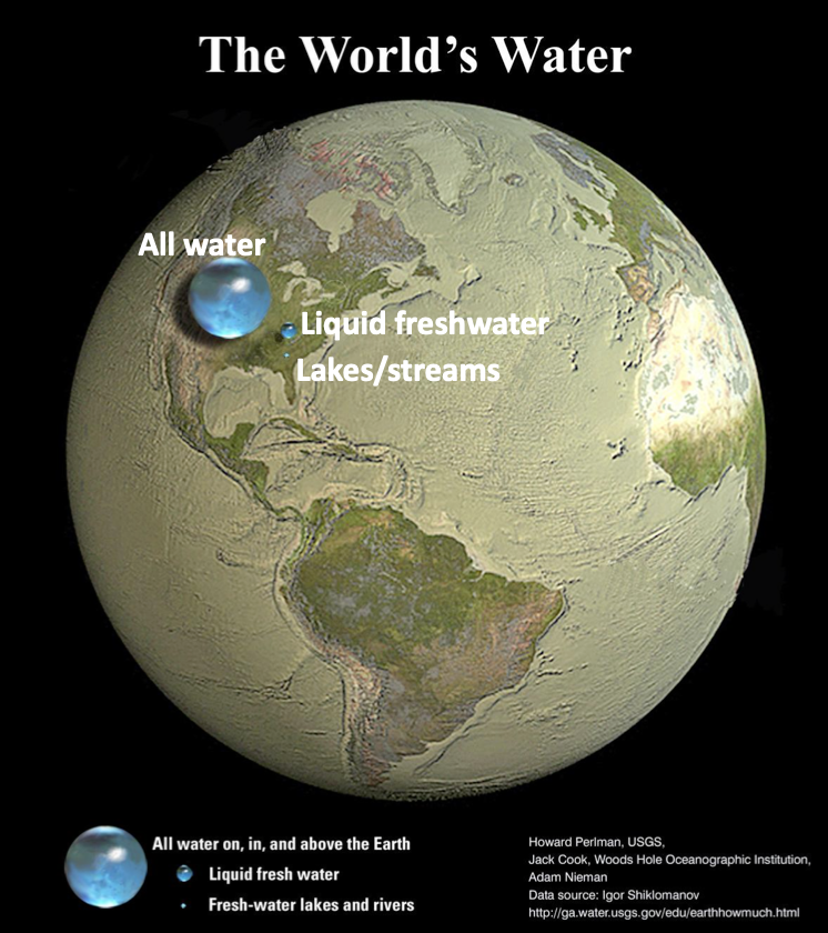
Reservoirs:
- Oceans
- Glaciers
- Groundwater
- Lakes/streams
- Soil moisture
- Atmosphere
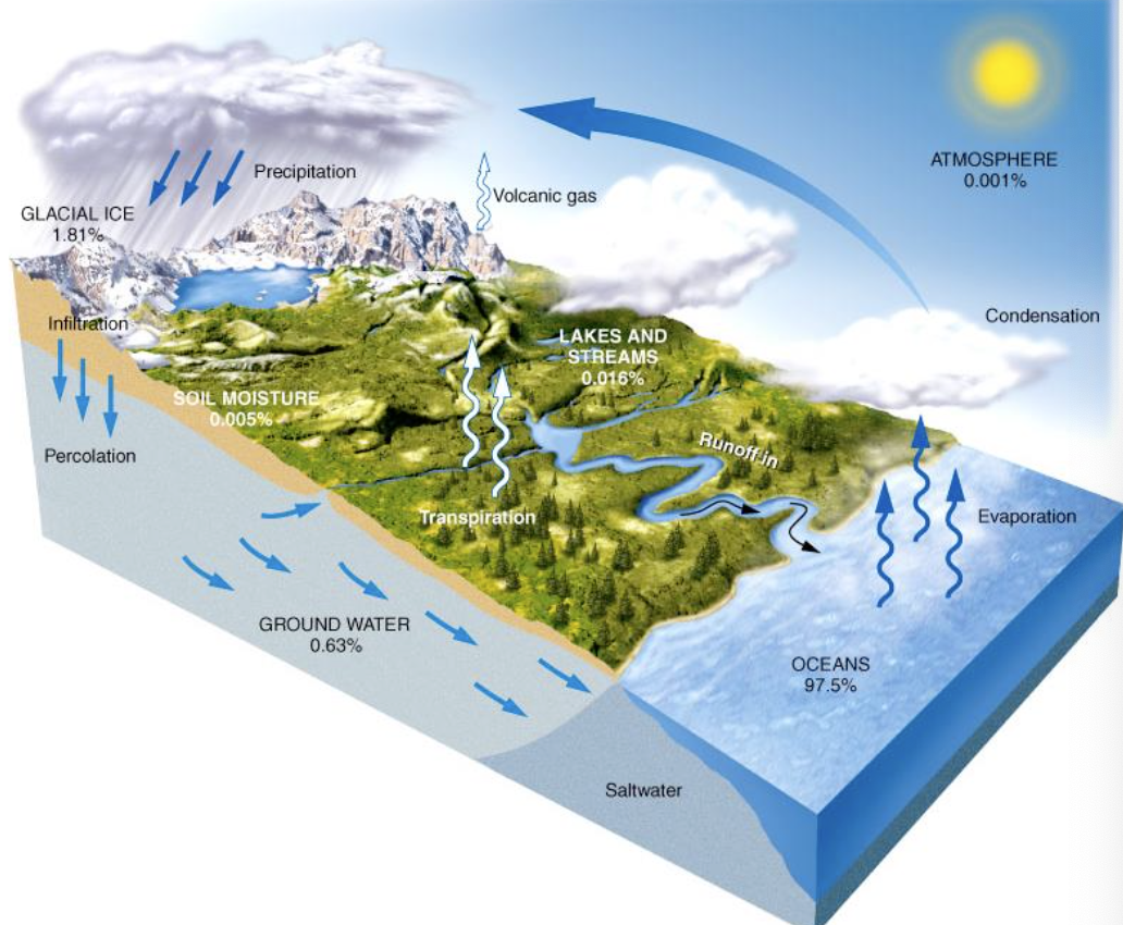
Hydrologic Cycle
The hydrologic cycle represents the movement (circulation) of water across reservoirs of hydrosphere.
Processes: Evaporation, Precipitation, Condensation, Transpiration, Runoff, Infiltration, Percolation
Why do we care about streams?
- Streams: any body of flowing water confined within a channel
- Water shapes the earth’s surface
- Streams are the dynamic agent of erosion, sediment transport and deposition
- Streams play a major role in human affairs
- Source of water for drinking, agriculture, industry
- Used for navigation, commerce, producing power, recreation
- Source of fresh water for all types of life, habitats, fisheries
- Floods are the most widely experienced catastrophic geologic hazard
- Need to understand controlling factors
- Determine ways to reduce hazard and impacts
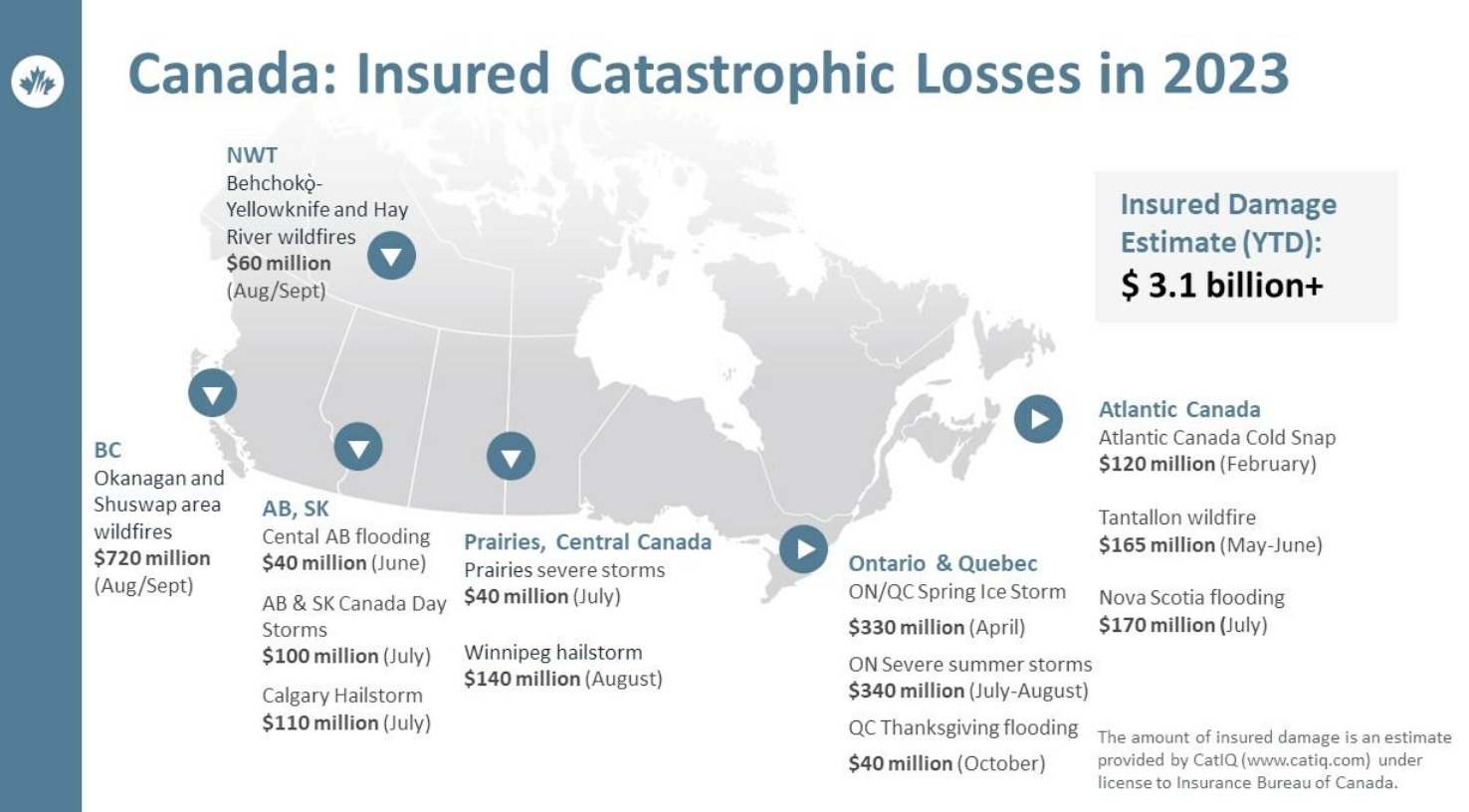
Flooding
Definitely the costliest of natural hazards: https://globalnews.ca/news/8388250/bc-floods-damage-cost-repairs-insurance-most-expensive-natural-disaster-canadian-history/
Two biggest flood drivers:
- Population growth and urban development
- Climate Change
Updates on flood insurance and potential relocation: Government page Public Safety Canada.
Streams
Streams
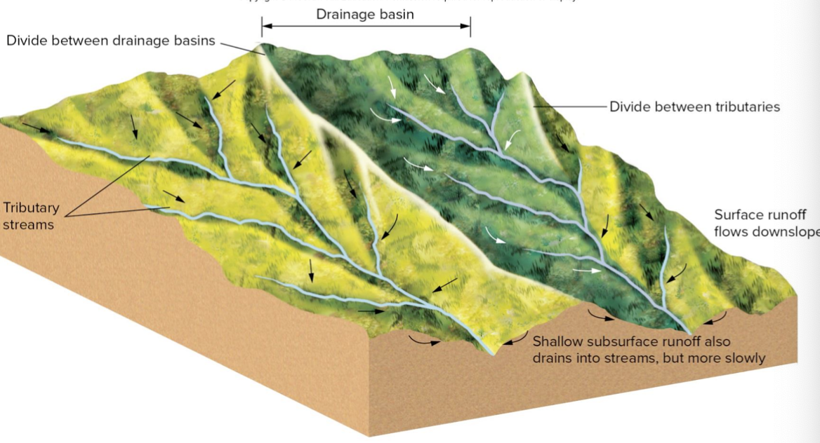
- Drainage basin (watershed): region from which stream draws water
- The channel carved by a stream is related to volume of water it accommodates
- More or less water over time means geography will change
- Tributaries are streams that feed into other streams, creating a network
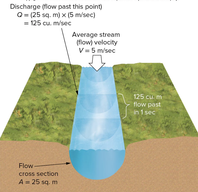
- Discharge: a volume of water flowing past a given point (or through a given cross section in a specified length of time)
, discharge
, area of cross section
, velocity of water
Sediment Transport
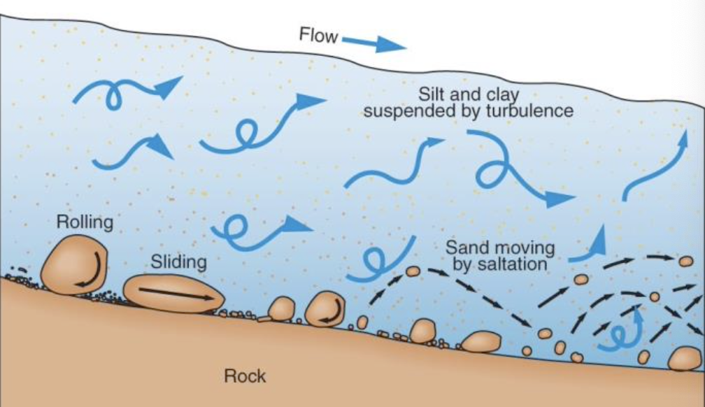
Bed Load:
- Heavy particles are rolled, dragged or pushed along the bottom of stream ⇒ traction load
- Intermediate size material is carried along in hops or skips ⇒ saltation
Suspended Load: Material that is light and fine enough to be carried along in the water ⇒ muddy appearance
Dissolved Load: Material dissolved in water ⇒ salt
Stream Load: Bed + Suspended + Dissolved loads
Capacity: total load of material a stream can move
Longitudinal Profile - sketch from source to mouth
Velocity is related to discharge and
• Gradient ⇒ difference in elevation between two points divided by horizontal distance between points
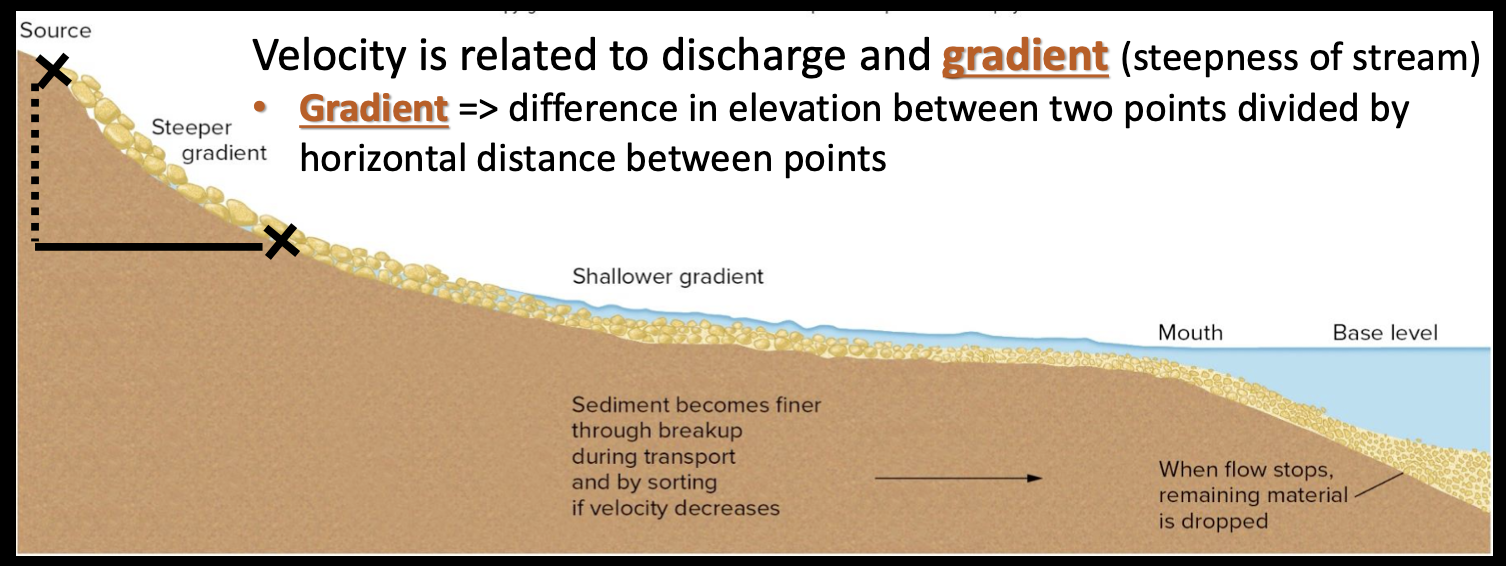
- Gradients tend to decrease downstream
- Velocity often decreases but depends on additional water from tributaries, friction at stream bed, and geometry of channel
- Near the mouth, stream approaches base level ⇒ lowest elevation to which the stream can erode, usually elevation of body of water they flow into
Sediment Sorting and Deposition
- Stream velocity dictates sediment sorting
- Slow-moving water only carries fine-grained sediments
- Fast-moving water carries a wider range of grain sizes
- Sediments are commonly well sorted by size and density • ⇒ like-sized grains deposited in same area
- Depositional features of a stream
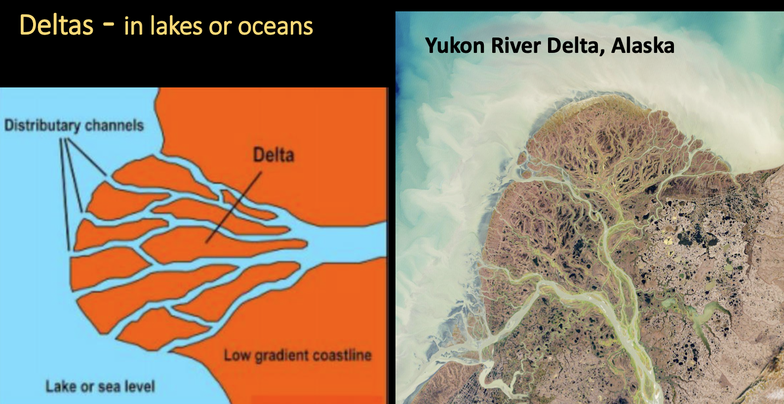
- Delta, a large, fan-shaped pile of sediment in still waters created by a stream
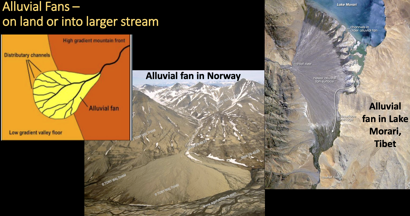
- Alluvial fan, a fan-shaped pile of sediment in a larger stream or a region between mountains and a plain formed by a small tributary stream
Deltas in lakes or oceans:
Alluvial Fans on land or into larger stream
Channels
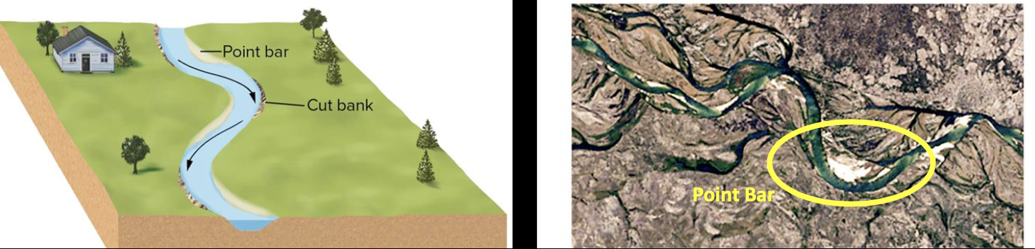
- Streams do not flow in straight lines, and they change shape over time
- Meanders: bends in the stream formed by flowing water
- Cut bank: outside of meander; faster and deeper water; erosional bank
- Point bar: inside of meander; slower, shallow water; depositional bank
Floodplain Development
- Meanders slowly migrate downstream over time
- Meanders move laterally quickly! Usually <10 m/y but up to hundreds of m/y possible.
Flood Characteristics
- Higher velocity and discharge during flood increases mass of flowing water ⇒ can lead to destruction
- Stream stage – elevation of stream at any point
- Flood stage – when stream stage exceeds bank height
- Crest – when maximum stage is reached
- Flooding can occur at different times along a stream depending on how long the water takes to reach those points
Types of floods:
- Upstream floods – small, localized areas flooded; typically, caused by sudden, localized storms; shorter as downstream regions accommodate excess water
- Flash floods – type of upstream flood; very rapid rise of a large volume of water in a confined area (no floodplain); steep-sided canyons or valleys and highway underpasses; can be extremely dangerous
- Downstream floods – larger drainage areas; caused by prolonged heavy rains or snowmelt; longer because whole system is at capacity
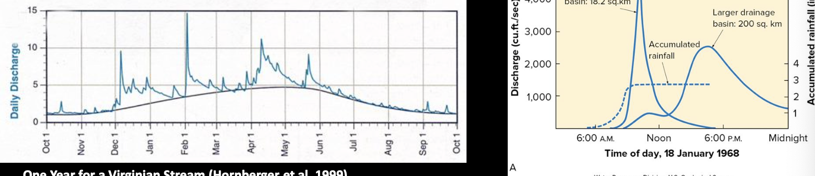
Stream Hydrograph
- Hydrograph – a plot of stream discharge at a particular location over time
- Show fluctuations in discharge or stream height over time
- Useful tool to monitor stream behaviour remotely
- Important information for detecting and predicting floods
- Create a Hydrograph - plot discharge/stage on vertical axis; plot time on horizontal axis
- Can see short and rapid peaks in small upstream areas
- Longer, broader peaks in larger downstream areas
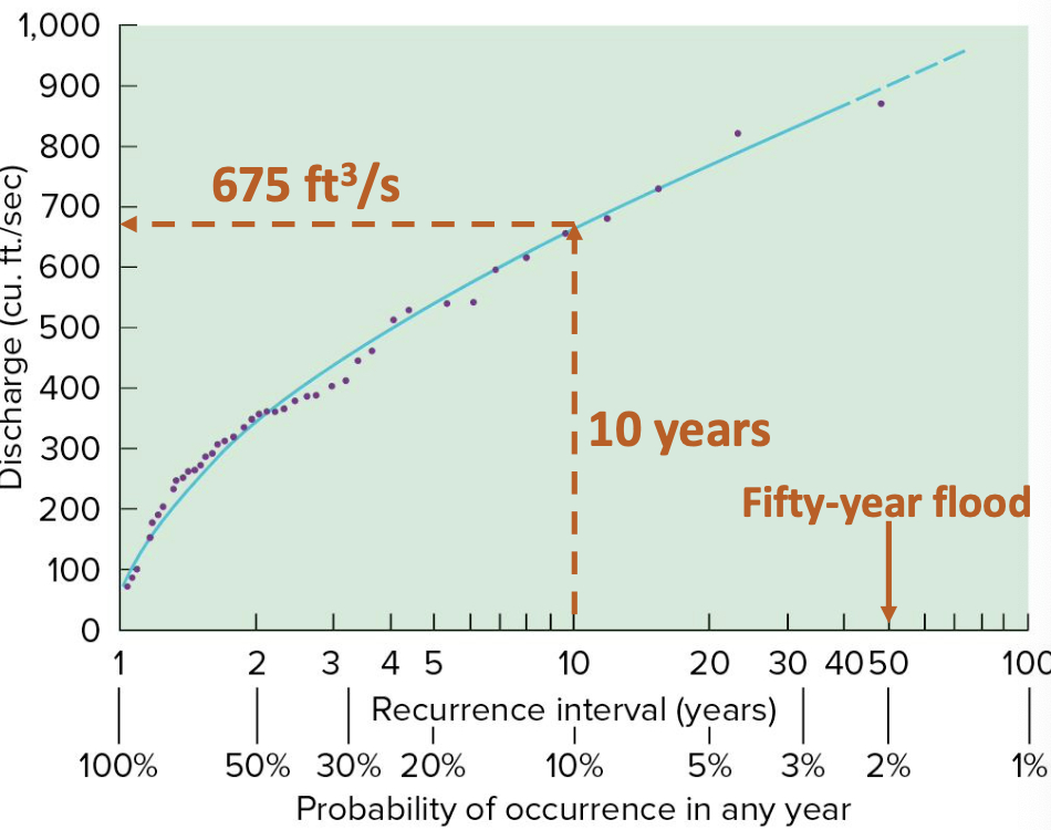
Flood-Frequency Curves
- Displays frequency of flood events
- Discharge as a function of recurrence interval or probability
- Recurrence interval–how frequently a flood of that severity occurs
- Probability–inverse of recurrence interval
- Fifty-year flood has a 2% chance of occurring (=1/50)
Development in Floodplains
Based on what you know about how floodplains work, would you live in one?
- Fertile land
- Water for power and transportation
- No idea where 100-year flood line is
- Peak lag time – time lag/delay between rain event and peak flood discharge
- Urbanization increases risk of flooding by decreasing peak lag time and causing a higher peak discharge in a shorter amount of time
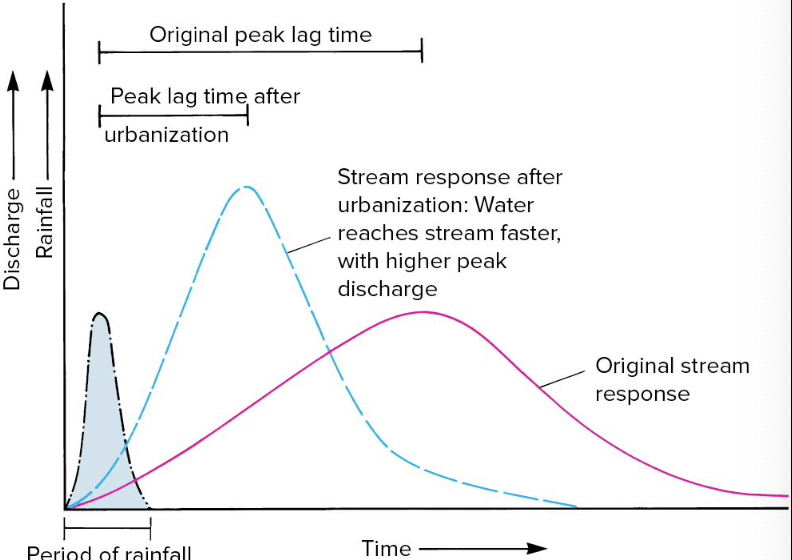
- Urbanization impacts surface runoff proportion and rate
- Asphalt and concrete - reduce infiltration
- Buildings - replaces water volume, raises stream height
- Filling in floodplain land - reduces volume (destroying wetlands)
- Storm drains - rapid delivery of storm water to streams
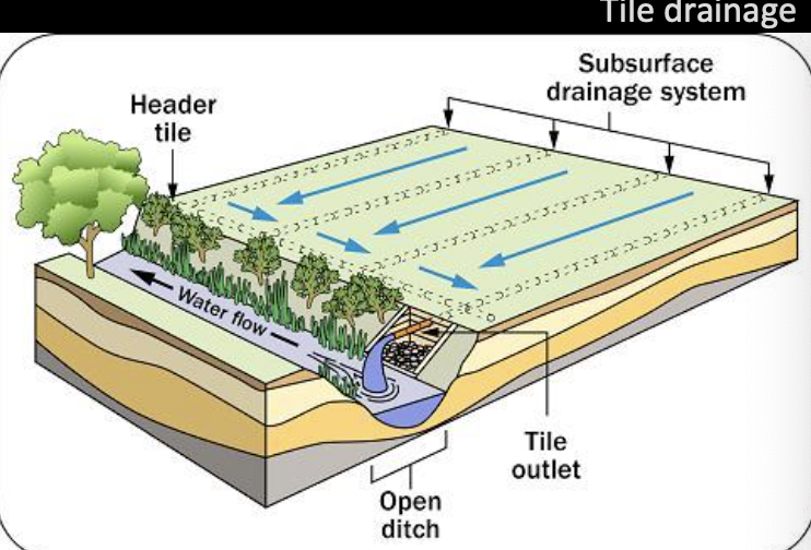
- Tile drainage farming – rapid delivery of subsurface water to streams
- Vegetation loss – farming and urbanization remove natural vegetation and expose the soil
- Vegetation helps soil soak up water and prevent soil erosion
- Streams can silt up – decrease volume and reduce capacity to carry away water
Reducing Flood Hazards
-
Restrictive Zoning: Careful mapping and placing features strategically (e.g., parks or pasture in flood zones, not residences); Building on stilts
-
Retention Pond: Build structure to trap some surface water runoff
-
Diversion Channel: Redirects some water into other safer places when levels rise
-
Channelization: Various modifications of the stream channel itself to increase the velocity of water flow, the volume of the channel, or both Recall Discharge, Q = Velocity x Area ⇒ increases discharge
- Widen, deepen, or straighten channel
- Use of concrete channels was common
- Constant maintenance often required
- Ecological impacts on wetlands, fish habitat, etc.
-
Levees: Ancient technique of raising banks along a stream channel
- Same as channelization, water is shunted downstream faster rather than onto floodplain
- Levees can be breached, and water is stuck
- Sedimentation raises stream stage, levees too low
-
Flood Control Dams and Reservoirs: dams built along stream to hold back water in a reservoir (an artificial lake)
- Benefits: irrigation water; recreation; hydropower
-
Cons: disruptions to navigation of people and animals; flooding of human and animal habitat
-
Silting-up of reservoir – can fill completely; needs constant dredging
-
Downstream impacts on vegetation and habitats
-
Earthquakes! Added pressure on rocks and faults from dam and reservoir
-
Dam failure does happen
-
Overuse of dam for multiple purposes with contrasting needs
Do Quiz 5!