Groundwater and Water Resources
Why are groundwater/water resources important?
- Drinking/bathing/washing
- Agriculture
- Industry
- Energy Sector
- Hydropower
- Extracting and refining fossil fuels
- Thermoelectric power – generate electricity with steam-driven turbines
- Cooling of power-producing equipment
- Plant and animal habitat
- Recreation
How much freshwater is there for us to use?
- Hydrosphere Reservoirs:
- Oceans - Majority is salty!
- Glaciers
- Groundwater
- Lakes/streams
- Soil moisture
- Atmosphere
Now forget these percentages!
Use from next slide!
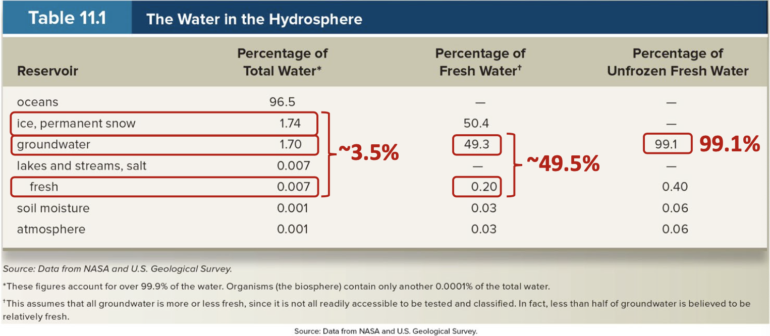
- ~3.5% of total water on Earth is fresh and ~49.5% of that is not frozen!
- An 99% of available freshwater is groundwater!
Renewable vs. Sustainable
- Freshwater is a renewable resource from a geologic (long term) perspective and in the short term for some regions.
- But freshwater is inadequate or non-renewable in the short term for some other regions.
- Sustainable Development: “meets the needs of the present without compromising the ability of future generations to meet their own needs.”
Info
- ~884 million people do not have access to safe drinking water
- 2 billion people do not have access to basic sanitation services
- ~3 billion people cannot wash their hands at home
Groundwater is part of Geology (hydrology) hydrogeology
- The presence, amount, and behaviour of subsurface water is related to the geology of an area
Porosity
The proportion of voids space (holes and/or cracks) in material (soil or rock) where fluids could be stored (as percent (1.5%) or decimal (0.015) of total volume)
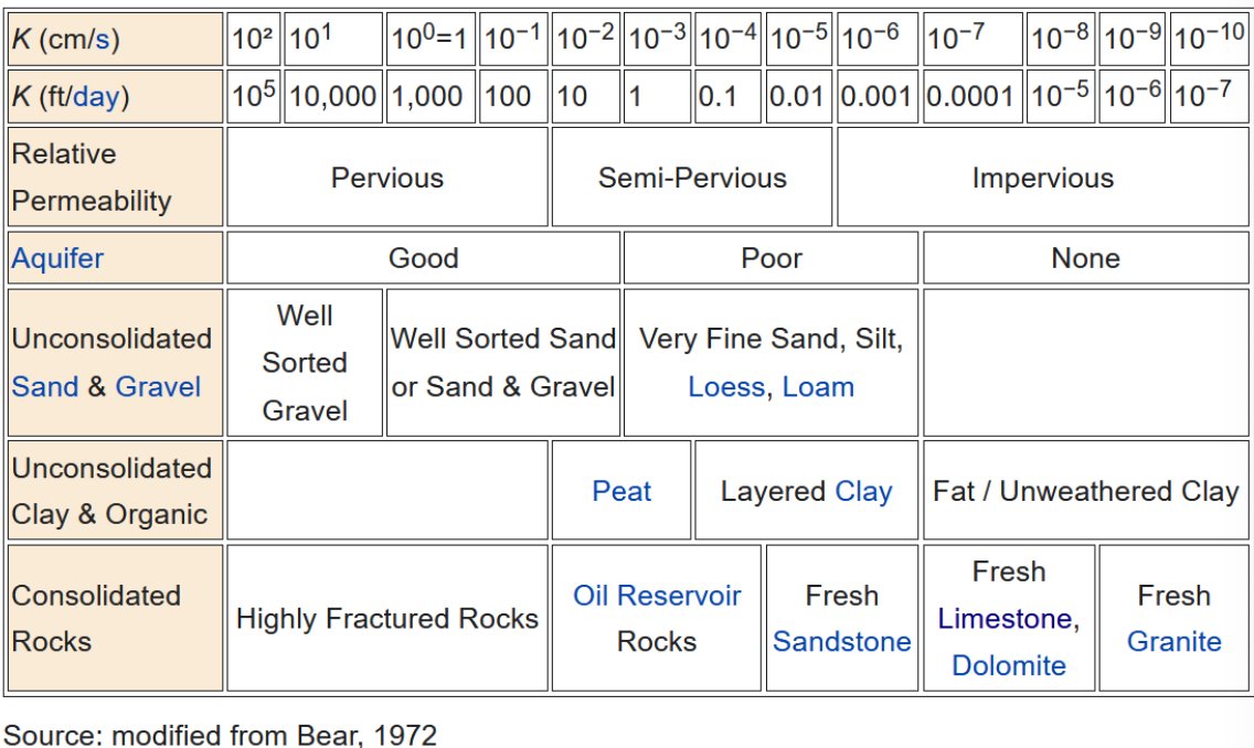
Permeability
Measure of how easily fluids pass through rocks, sediments, or soils and is related to the interconnectedness of pores (as or millidarcies)
Porosity and permeability depend on the shapes and sizes of the grains and how they fit together
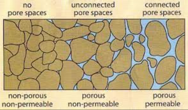
Hydrogeology
- A. Igneous rocks usually have tightly fit crystals low porosity and permeability
- B. Sandstone (sedimentary) rock with round grains of similar size high porosity and permeability
- C. Poorly sorted sedimentary rocks lower porosity but still permeable
- D. Clastic sedimentary rocks with flat, platelike grains porous but not very permeable
Subsurface waters
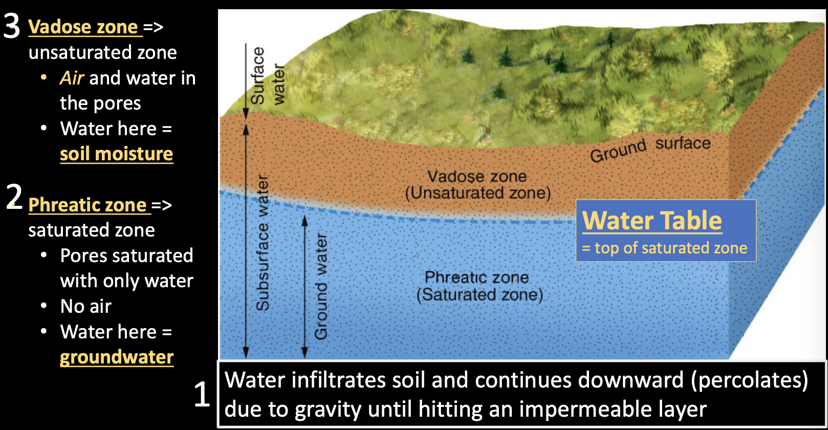
Phreatic Zone
Saturated zone
- Pores saturated with only water
- No air
- Water here = groundwater
Vadose Zone
Unsaturated zone
- Air and water in the pores
- Water here = soil moisture
- Precipitation infiltrating unsaturated zone will mostly recharge groundwater
- Streams can also help recharge groundwater
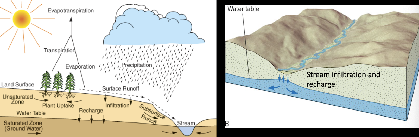
Water table can change height
- With topography
- With seasonal precipitation
- With human-induced extraction
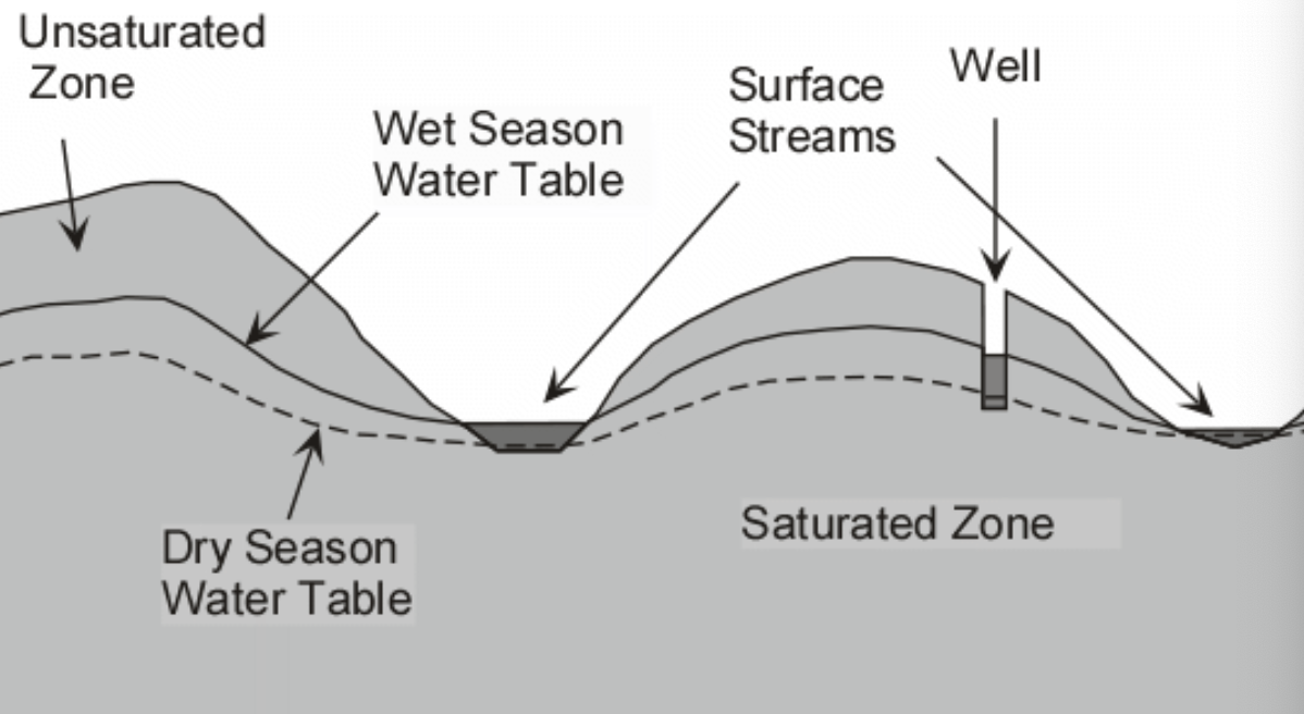
Water table can intersect ground surface to become surface water:
- Lake
- Stream
- Wetland
- Spring Groundwater discharge
Aquifers
Aquifer
Rock or soil porous enough to hold a useful amount of water and permeable enough so that water can be transported easily
- Clastic sedimentary rocks, like sandstones
- Fractured or weathered rocks
Aquitard
Rock with lots of water but the permeability is too low to be useful for obtaining water
- Shales
-
Unconfined aquifer
- Directly overlain by permeable materials
- Aquifer is recharged easily
- Water is easily obtained
-
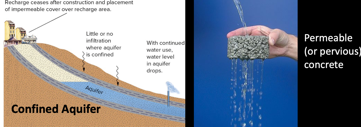
Confined aquifer
- Bounded above and below by aquitards
- Typically takes years to centuries to recharge
- Depleting these is not sustainable
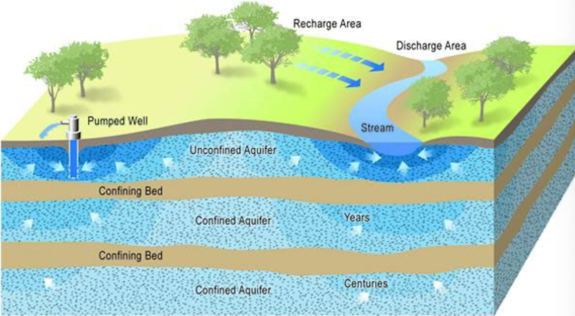
-
In confined aquifiers, water elevation exerts pressure on water at low elevations
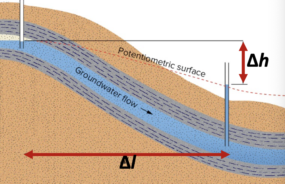
Potentiometric surface
Height that water level rises because of pressure and as if it was unconfined
Artesian well
Water rises above a level in an aquifer due to natural pressure
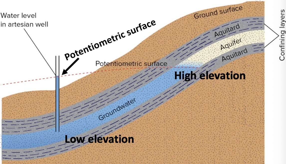
- Artesian water, by definition, has nothing to do with the chemical quality of the water
- It’s simply water from a well under natural pressure
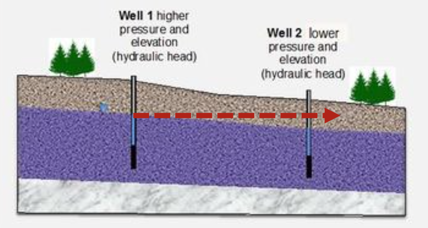
Groundwater Flow
- Permeability governs the ease of groundwater movement
- Hydraulic head controls where and how rapidly groundwater flows
- A measure of the potential energy of the water at that time
- Height of the water table (unconfined aquifer) and potentiometric surface (confined aquifer) represents the hydraulic head at that point
- Bigger the difference between hydraulic head, the faster water will move
Darcy’s Law
-
discharge
-
cross-sectional area
-
hydraulic gradient
-
hydraulic conductivity considers permeability of the rock/soil and viscosity and density of fluid
-
, hydraulic conductivity, determined empirically (e.g., correlating with soil properties, like grain size) or experimentally using Darcy’s Law
-
Higher the , easier and faster the flow
Consequences of Groundwater Withdrawal
-
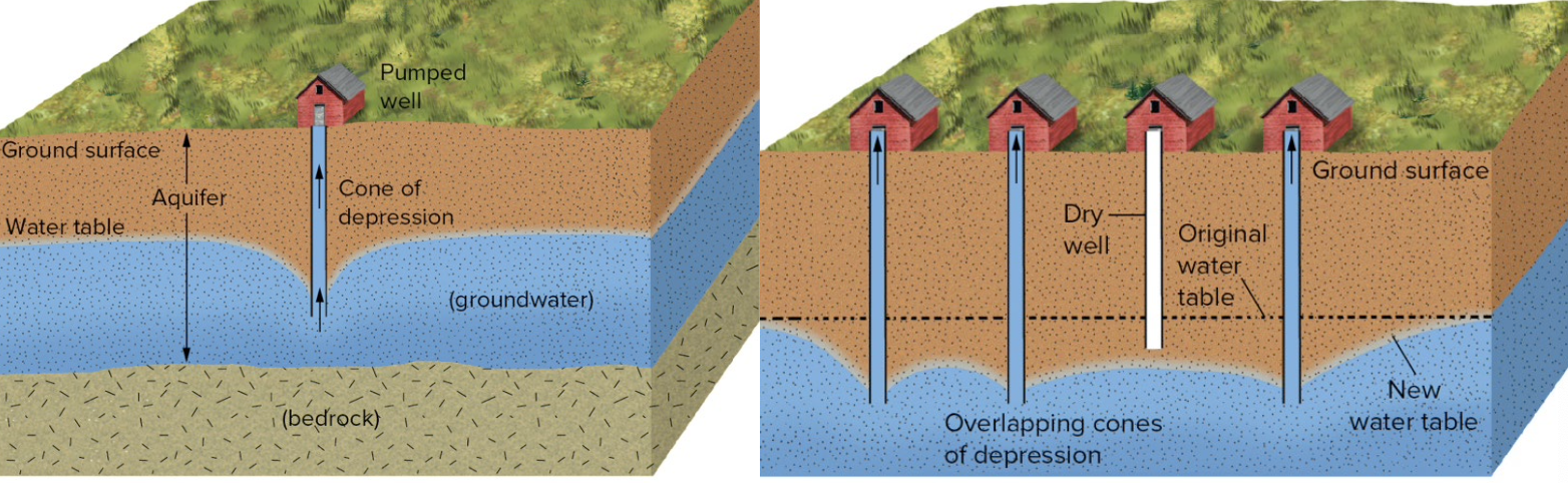
Withdrawal could lead to lowering of the water table
- Cone of depression near a well: very localized lowering of water table
- Multiple wells could cause larger scale lowering of water table
- When withdrawal >> recharge, water table may stay low or wells bottom out
-
Extraction near cities may be dramatic
-
Chicago’s water table was drawn down by ~800 ft (~245m) between 1864 and 1980
-
Withdrawing water/lowering water table leads to compaction of aquifer rocks by weight of overlying rocks
-
When soils or rocks settle, land may subside, and flooding is possible
Venice, Italy is sinking!
- Groundwater extraction
- Weight of buildings
- Rising sea levels Sunk by about 9 inches (23 cm) in last century
- Saltwater intrusion in coastal areas
- Less dense freshwater on top of denser saltwater
- Extraction leads to upconing (cone of ascension) of saltwater below cone of depression
- Saltwater can destroy an entire aquifer (e.g., Brooklyn, NT, USA in the 1930s due to industrial water us)
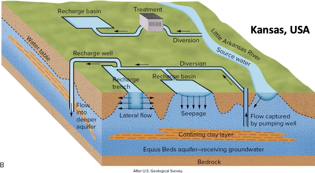
- Can prevent intrusion if keep the aquifer full (e.g., wastewater treated and pumped back in beneath Orange County, CA, USA)
Urbanization and Groundwater Recharge
- Buildings, asphalt and concrete will NOT impact an unconfined aquifer much
- Infiltration will continue over the typically large recharge zone
- Confined aquifers have small recharge zones that should not be built over
- Filling in wetlands could have been a natural accumulation spot for recharge water
- Restored wetlands in Florida, USA are filled with reclaimed water for multiple purposes including recharging aquifer
- Artificial recharge basin: catches surface runoff on sloped ground that is stored for infiltration
- Stream diversions and more complicated drainage projects may be necessary
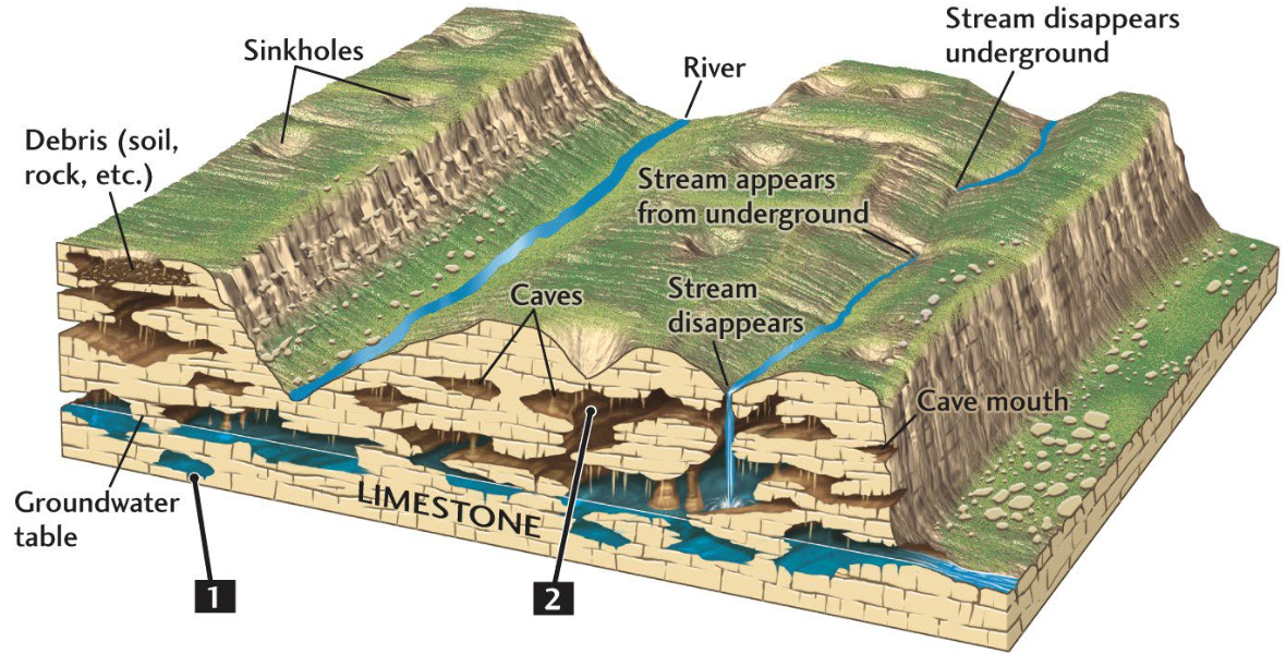
Karsts an Sinkholes
Karst
Distinctive looking terrain of rocks that have been heavily dissolved by subsurface water
- Carbonates (limestone and dolomite), rock salt, gympsum
- Underground karst includes large voids and caves great for water storage
- 40$ of USA’s groundwater-sourced drinking water is from karst aquifers But…
- Difficult to estimate supply
- Unpredictable supply
- Rapid flows quickly spread contaminants (m/d, not cm/d)
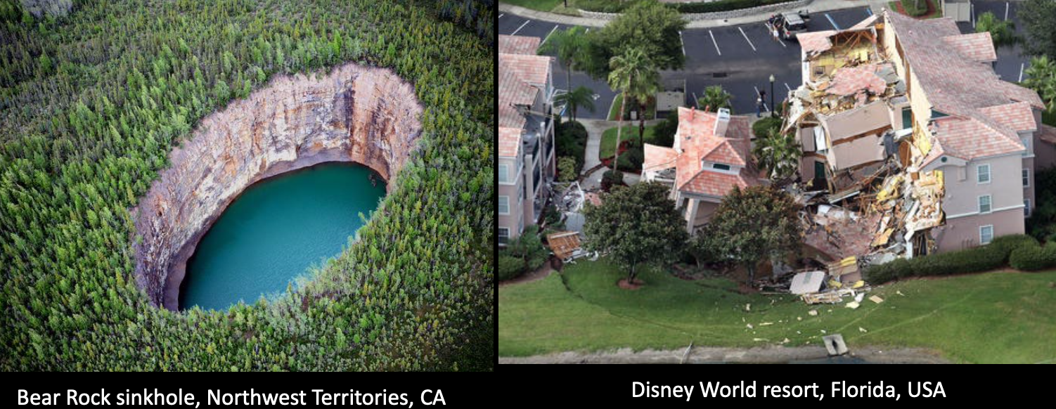
Sinkhole
Ground collapsing abruptly into a large void in underlying karst
- Triggered by drought or water use that leaves overlying rocks / soil unsupported, or heavy rains transporting soils into caverns
http://www.geologyontario.mndm.gov.on.ca/mndmfiles/pub/data/imaging/GRS005/karst-map.pdf
Natural Water Quality
-
Dissolved chemical measurements
- Typically, parts per million (ppm) or parts per billion (ppb) ⇒ very dilute
-
Total dissolved solids (TDS)
- Sum of concentrations of all dissolved chemicals
- Cations: calcium, magnesium, sodium, potassium
- Anions: carbonate, bicarbonate, chloride, sulphate, nitrate
- Canadian drinking water standard is < 500 ppm, but taste depends on what is in it
-
pH
- Measure of acidity (or hydrogen ions in water)
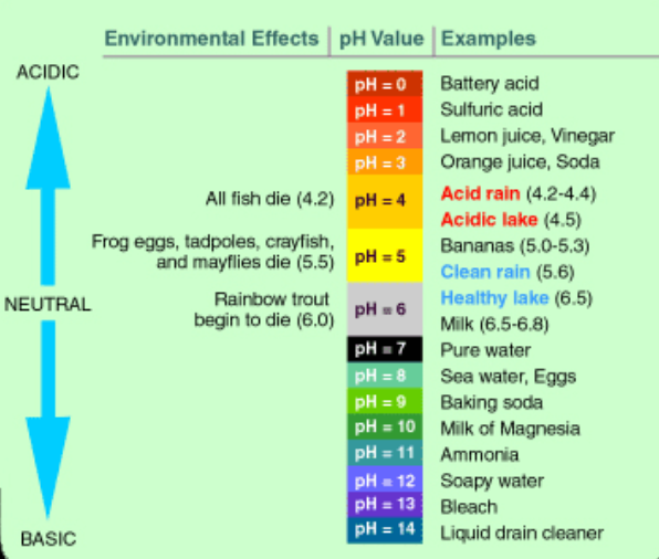
- Measure of acidity (or hydrogen ions in water)
-
Radioactive elements of concern
- Uranium from aquifer or nearby rocks Radium (concentrates in teeth/bones) and Radon (air pollution)
-
Hard water: substantial amount of dissolved calcium and magnesium
-
Not dangerous, just annoying
-
100 ppm (or mg/L) becomes obvious in Canada
-
Softeners replace Ca, Mg with Na and remove radium too
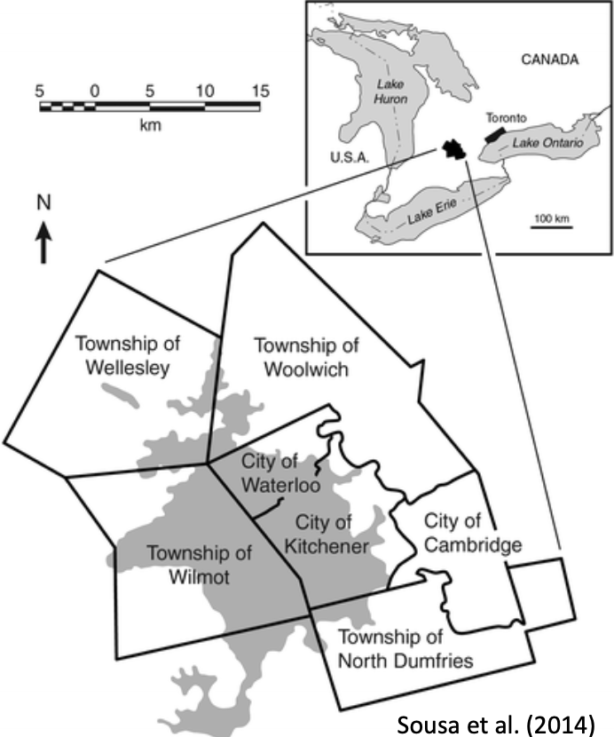
Waterloo Moraine Aquifer
- 45% of drinking water from Waterloo Moraine, 35% from other groundwater sources, and 20% from surface waters
- Waterloo Moraine supplies 75% of overall water needs
- Waterloo Moraine was glacially formed – till from Laurentide Ice Sheet – 30-100 m thick
- It is confined to semi-confined, overlain by a glacial aquitard
- Recharge area is on west end
- Developments in the west could create impervious regions and slow recharge
- Contaminants from agriculture, residential, industry, and road salt are biggest concern
- Water travels west to east and feeds many of our streams and wetlands
Water Use in USA
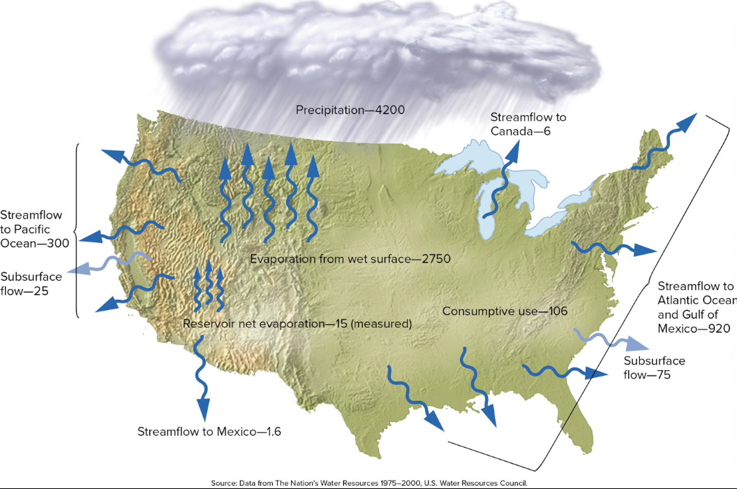
Water Budget:
-
4200 billion gallons/day of precipitation
-
Subtract 2750 billion gallons/day of evaporation
-
1450 billion gallons/day for surface and groundwater
-
Humans personally need a gallon of water per day (4 liters): drink/wash
-
In USA, 330 million gallons per day for a population of 330 million
-
But >350 billion gallons per day are used for household, industry, power, agriculture (offstream use) and several trillion for hydropower (instream use)
-
100 billion gallons per day are consumed (not returned) - and groundwater takes years or centuries to fully recharge
Why not build reservoirs to easily capture water and use it instead of bothering with groundwater?
- USA has ~84,000 dams holding 158 trillion gallons of water
- But reservoirs can lose over half of their water via evaporation (depending on climate)
- Reservoirs lose 79 trillion gallons per year from evaporation > consumption by industry and households!
Surface waters dependent on precipitation, which is not evenly distributed and may not correlate with population density and water use.
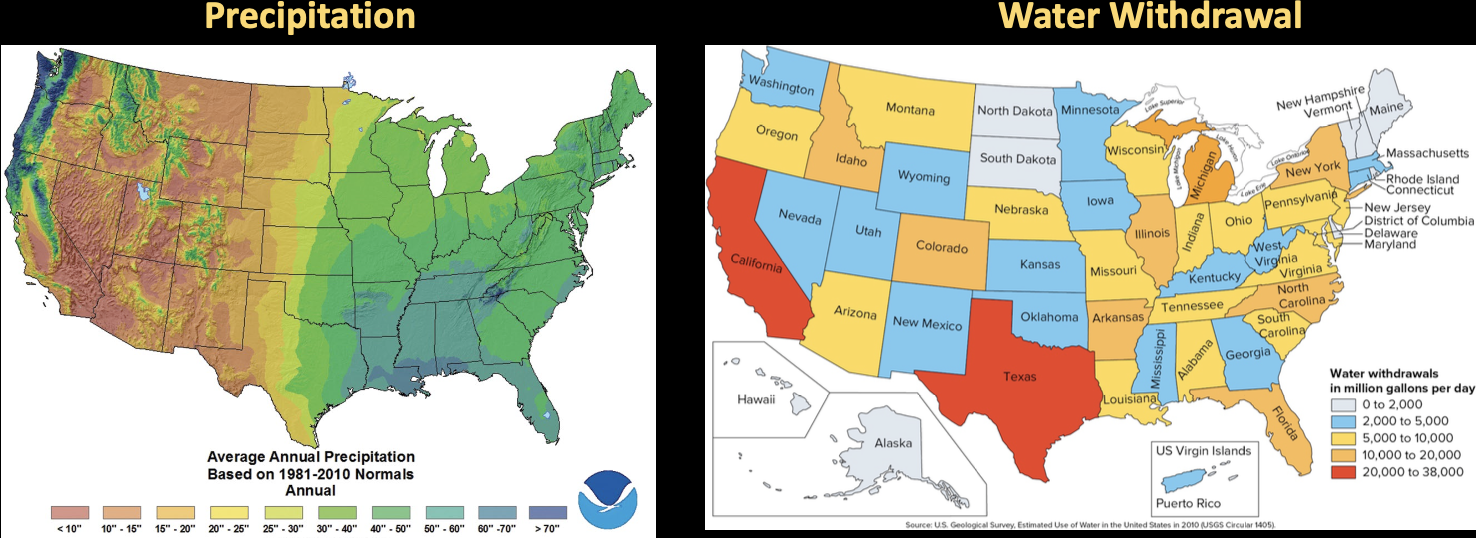
Groundwater is a larger and more reliable water resource/supply! It is also a natural filter… groundwater is often cleaner and needs less potential treatment than reservoirs.
- Even though groundwater is reliable, it is only contributing ~22% to USA water use.
- Half of groundwater is used for irrigation
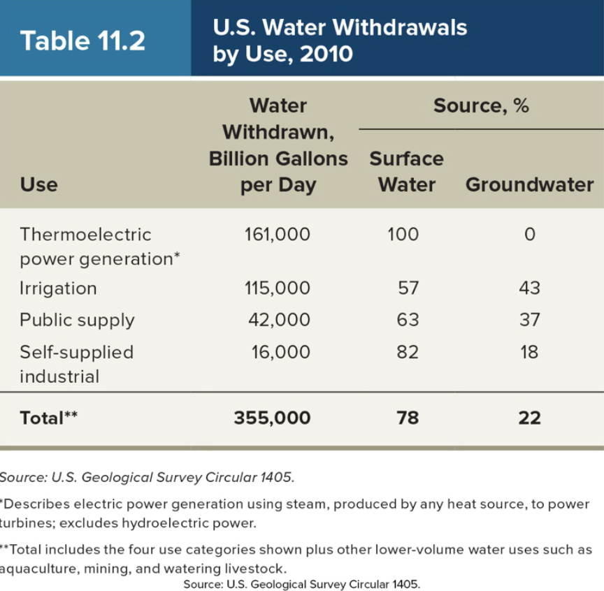
- Thermoelectric power generation is the largest water user, but they return almost all the water to the location it was retrieved and consume very little
- Irrigation water is heavily consumed - lost to evaporation, transpiration through plants, and leakage from ditches / pipes.
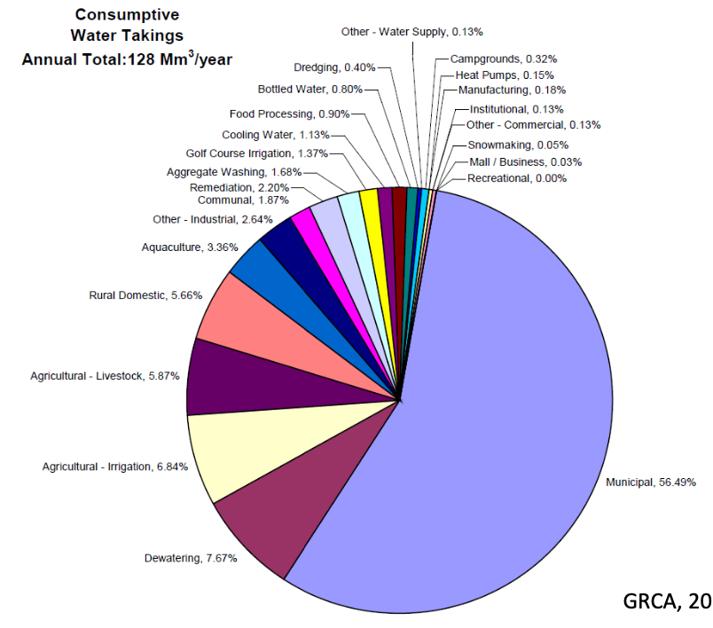
Our Regional Consumptive Water Uses
Grand River Watershed
-
Consumptive Water Taking
-
Annual Total: 128 Mm3/yr
-
Municipal, 56.49%
-
Irrigation, 6.84%
-
Livestock, 5.87%
-
Golf courses, 1.37%
-
Food Processing, 0.90%
-
Bottled Water, 0.80%
Extending our water Supply
- Conservation
- Reduce loss (fix pipes or plumbing)
- Don’t water lawns
- Don’t have pools
- Eat less meat
- Irrigation is the biggest issue!
- Change crops
- Reduce evaporation microirrigation
- Reuse water more efficiently: in houses, buildings, cities
- Interbasin transfer
- Aquaducts to transport water to drier regions
- But source can dry up
- International boundaries are tricky
- North American Water and Power Alliance
- 1950s/1960s, never done
- Water from Alaska/Canada through Canada to USA and Mexico
- Desalination
- Filtration systems – seawater clogs the filters
- Best for low salinity waters
- Distillation – boiling off water and leaving behind
- Works well for saltwater, but requires energy
- Sunlight could be used but need a large shallow area
- Expensive, especially for irrigation
- Need to provide adequate drinking water for humans and plants Dubai, UAE
- Filtration systems – seawater clogs the filters
- Can only meet 0.5% of population’s water demands with freshwater supplies
- 9.5% comes from desalination of Persian Gulf water
- Need: 416 million gallons per day
- Jebel Ali Plant supplies 2.8 billion gallons per day