SCI 250: Environmental Geology
Taken during Winter 2024. Fulfills science elective.
Comes with slides. Suggested reading: Environmental Geology, 12th Edition (2023), by Carla W. Montgomery and [Gina Seegers-Szablewski](https://blackwells.co.uk/bookshop/search/author/ Gina Seegers Szablewski) (McGraw-Hill Higher Education)
Assessment:
- Exams 50%
- Assignments 30%
- Quizzes 20%
Schedule:
Content
Week 1
- Big Bang
- Galaxie
- Solar System
- Earth
- Geology
- Population Growth
- Elements
- Radiometric Dating
- Mineral
- Rock
Week 2
Week 3
Week 4
Week 5
Week 6
Week 7: Reading Week
Week 8
- Exam 1
Module IV: Resources
Week 9
Week 11
Week 12 - Module V: Waste & pollution
Activity
- Activity 1 - Population Growth by Country
- Activity 2 - Natural Disasters in the Media
- Activity 3 - Grand River Watershed Reservoirs Infographic
- Activity 4 - Pros & Cons of Alternative Energy
- Activity 5 - Environmental Geology at Home
Exam 2
Format
- 48 total questions for a total of 62 points (plus 4 easy survey questions for 2 total Bonus points)
- Breakdown:
- 5 x 1 pt questions per lecture (2 True/False and 3 Multiple Choice) - Similar to quizzes
- 4 x 2 pt questions (1 per 4 different lectures) - Similar to random assorted questions in quizzes that you may have seen before
- 2 x 3 pt questions (1 per 2 other lectures) - Similar to written questions you had on Exam 1
- 2 x 4 pt questions (1 per 2 other lectures) - Similar to written questions you had on Exam 1
Study Tips
- Quizzes should all be open for you to view correct answers - go over these again
- Focus on terminology (highlighted yellow in slides)
- Pay attention to figures of all types - charts, graphs, tables, schematics, real photos
- Understand general concepts
- See the review slides posted alongside this general information for more details to focus on in each lecture
Topics to focus on in Resources Module
Mineral and Rock Resources
Types of mineral deposits and examples of the rocks/minerals/formations associated with those types;
Types of Mineral Deposits
- Igneous Rocks and Magmatic Deposits
- Pegmatites
- Crystal settling
- Kimberlites
- Hydrothermal Ores
- Veins
- Galena for lead
- Sphalerite for zinc
- Bornite for copper
- Gold, silver, platinum ores
- Sedimentary Deposits
- Banded iron ore/formations
- Evaporites
- Halite (table salt)
- Gypsum (plaster)
- Low-temperature ore-forming processes
- Placers - after minerals are weathered out of local rocks, transported by streams, and mechanically concentrated by the water
- E.g. Gold, diamond, tin oxide
- Bauxite - main source of aluminum, found in tropics with heavy rains
- Placers - after minerals are weathered out of local rocks, transported by streams, and mechanically concentrated by the water
- Metamorphic Deposits
- Graphite (pencil lead)
- Garnets common in metamorphic rocks
- Asbestos
- Hydrothermal and igneous deposits often located along plate boundaries, especially subduction zones.
Mineral and Rock Resource Examples
- Metal
- Iron - most heavily used metal and most commonly found
- Iron-banded ore, laterites, magnetite in igneous rocks
- Aluminum - second most widely used
- Plentiful in crust but hard to extract; Mostly from bauxite (laterite)
- Copper, lead, zinc, nickel, cobalt
- Common in sulfide ore deposits but also in sedimentary ones
- Gold, silver, platinum
- Common in igneous or hydrothermal ore deposits
- Often a by-product of mining more abundant metals
- Nonmetallic Minerals
- Sulfur - by-product of mining sulfides - for sulfuric acid in industry (acid rain)
- Halite, gypsum from evaporites
- Phosphate rock and potassium-rich potash are evaporites mined for P and K for fertilizer
- Clays - useful in construction materials
- Rock resources
- Most abundant quantity of earth resources we use!
- Why?
- Includes sand, gravel, limestone, quartz-rich sand, marble, granite, and sandstone
- Used for construction, cement/concrete, glass, fracking, and decoration
Do we need to know mineral exploration methods??
There are four main mining methods:
- Underground
- Miners need to go underground
- Surface (quarries, open pit, & strip mining)
- Dig downward with open top
- Placer
- In stream beds (commonly by dredging)
- In-situ mining
- Dissolving leached minerals and pumping to surface
Lecture 12 - Energy Fossil Fuel
Fossil Fuels
types of fossil fuels; how abundant are they relatively speaking and what is the future potential; what types of rock are they usually found in; how are they formed and then kept underground; what features of the reservoir and seal rocks help with their function; what is the progression of petroleum formation
-
How are they formed?
- From tissues of organisms (plants and animals)
- Organic materials (carbon) broken down in an anaerobic environment
- Conditions: lots of organic matter, high sedimentation rates, anoxic sediments
- Over time, compaction of the sediments generates kerogen
- Kerogen eventually breaks down further into hydrocarbons, such as coal, petroleum/oil, or natural gas
-
How are they kept underground?
- Petroleum Traps (multiple types of traps exist to keep the petroleum in the reservoir rock)
-
What features of the reservoir and seal rocks help with their function?
- Fine-grained sedimentary rocks with low permeability (e.g., sandstone) are most common reservoir rocks
- Accumulating rock (reservoir must be porous enough to hold a lot of oil or gas AND relatively permeable to allow it to flow when drilled.
-
How abundant are they relatively speaking and what is the future potential?
- Half the amount of oil since 1995 or something like that
- Unlikely to find new resources
- Unlikely to conserve
- Prices will only go up?
Lecture 13 - Alternative Energy sources https://quizlet.com/392108301/ch-15-alternative-energy-sources-flash-cards/
https://quizlet.com/7309195/geology-exam-2-flash-cards/
Alternative Energy
know the different types; generally, how they work and where are they located; pros/cons of them; where is uranium found; lifetimes of the different energies
Three broad categories:
- Nuclear
- Hydropower
- Renewables
Nuclear Power: Fission and Fusion, Solar Energy, Geothermal Energy, Hydropower, Ocean Energy, Wind Energy, Biofuels
Nuclear Power - Fission
- U235 fuels most fission reactors
- Fire a neutron at a U-235 nucleus to begin the chain reaction
- Nuclear is NOT renewable energy source but it is clean ⇒ no GHG emissions
- Cons: Safety concerns related to nuclear reactor, Safety concerns related to fuel and waste handling (cancer, plutonium from breeder reactors is radioactive and toxic)
Solar Energy
- Renewable energy: sun will always be there
- Free and clean energy
- Cons: limitations in terms of latitude and climate
-
- Solar Heating
- Passive solar heating: no mechanical assistance
- Active solar heating: mechanical circulation of solar-heated water
-
- Solar Electricity
- Photovoltaic cells
- Pros: no moving parts, no pollutants emitted
- Cons: expensive, technology not efficient and not mass produced, solar energy output is not efficient, and not efficient for scaling up ⇒ requires lots of land and resources, limitations: storage
Geothermal Energy
- When groundwater is heated enough, you can use steam to turn a turbine
- Only more than just 40 geothermal power plants: locations must align with plate boundaries (where magma is near the surface)
- Pros: no ash, radioactive-waste or emissions
- Cons: some sulfur emissions, corrosion of pipes, land subsidence and earthquakes
- Limitations:
- Field only lasts a few decades
- Stationary
- Only occurs in certain locations
- Limitations:
Hydropower
- Typically consists of damming a river, flooding an area, and controlling the release of water through turbines in the dam
- 4 main types
-
- Impoundment: flooding an area to become a reservoir
-
- Run-of-river: placing a dam in a river with limited flooding of area
-
- Diversion: diverting river water to a channel and use elevation decline to bring water to turbines (may not use a dam)
-
- Pumped storage: pump water uphill with solar, wind or nuclear energy and store it in a reservoir until energy needed and release down hill to turbines
-
- Pros: water is not consumed, renewable if river continue to flow, technology for storage is known, very clean
- Cons: problems associated with dams
- Silting-up of reservoirs
- Habitat destruction
- Evaporation
- Earthquakes
- Displacement of communities
- Dam failure risk (beware of fault zones)
- Sites are hard to come by now
- Need to transmit power long distances from remote areas
- Opposition to destroying land
- Revamping flood control dams may not work
- Must be stationary - on site power generation
- Impacted by climate ⇒ drought is the biggest issue
Ocean Energy
- Energy from tides, from waves, and from temperature differences between shallow and deep water
- Cons:
- tidal power needs 5 m difference or a dam to store water in a bay, but tidal differences in most areas only ~1 m ⇒ regions are limited
- total potential globally is only 2% of hydropower potential
- OTEC (Ocean Thermal Energy Conversion) exploits temperature difference between warm surface water and cold deep water
- Pros: clean, renewable, recondensed vapour is freshwater and can be used for water supply
- Cons: only near shore where cold water can be reached and only where temperature difference is 22 year round (tropical islands)
- Only operational facilities in Japan and Hawaii.
- Wave Energy
- up-and-down motion of water ⇒ exploit that
- Pros: clean and renewable
- Cons: eyesore and disrupts sedimentation
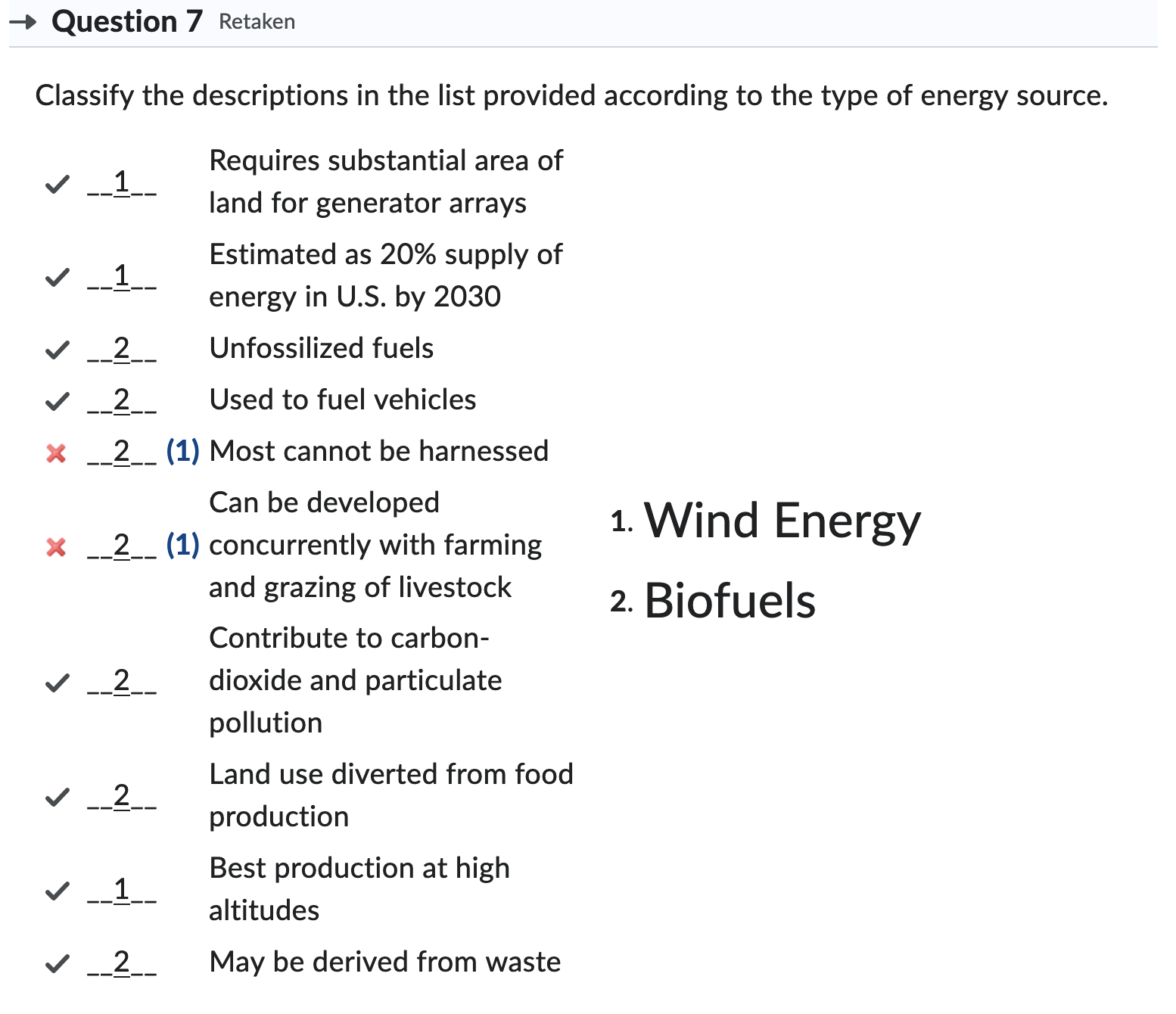
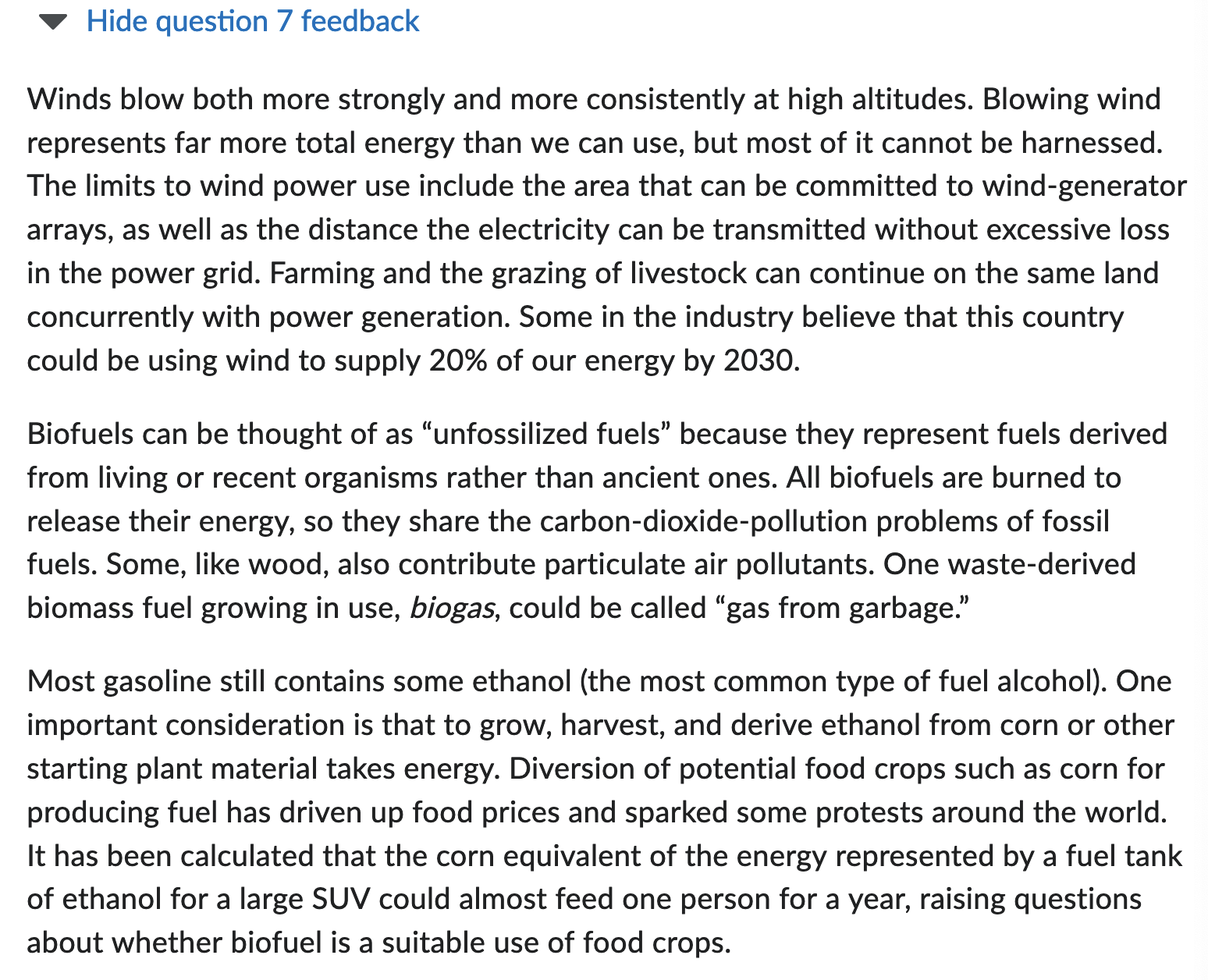
Wind Energy
- Pros: clean, renewable
- Cons:
- Old technology
- Limitations:
- 3D and highly variable in time
- Regional variability important for local power supply
- Needs to be windy and accessible (not too remote)
- Long distance transmission still inefficient
- Visual eyesore and noisy
- Interference with birds
- Disruption of communications
- Offshore wind farms more consistent than on land and can be near large cities.
- Cons: storage, aesthetics and jurisdiction are issues
Biofuels
- various ways to derive energy from living biomass or their remains
- 3 broad categories
-
- Wood
-
- Waste
-
- Alcohol
-
- Cons: All burned so they emit
- Some contribute particulate air pollutants (i.e., wood)
- Pros: All renewable (plant and use)
- Waste-derived fuels
- logging waste, crop waste, urban compost, liquid waste research, biogas or ‘gas from garbage’ ⇒ Methane = natural gas
- Alcohol fuels (bioethanol)
- Cons: GHG emissions
Water/Groundwater Resources
what are the basic groundwater features (different types of aquifers and wells) and associated terms; what do porous and permeable mean; what is recharge; what are the impacts when too much water is extracted
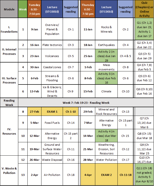
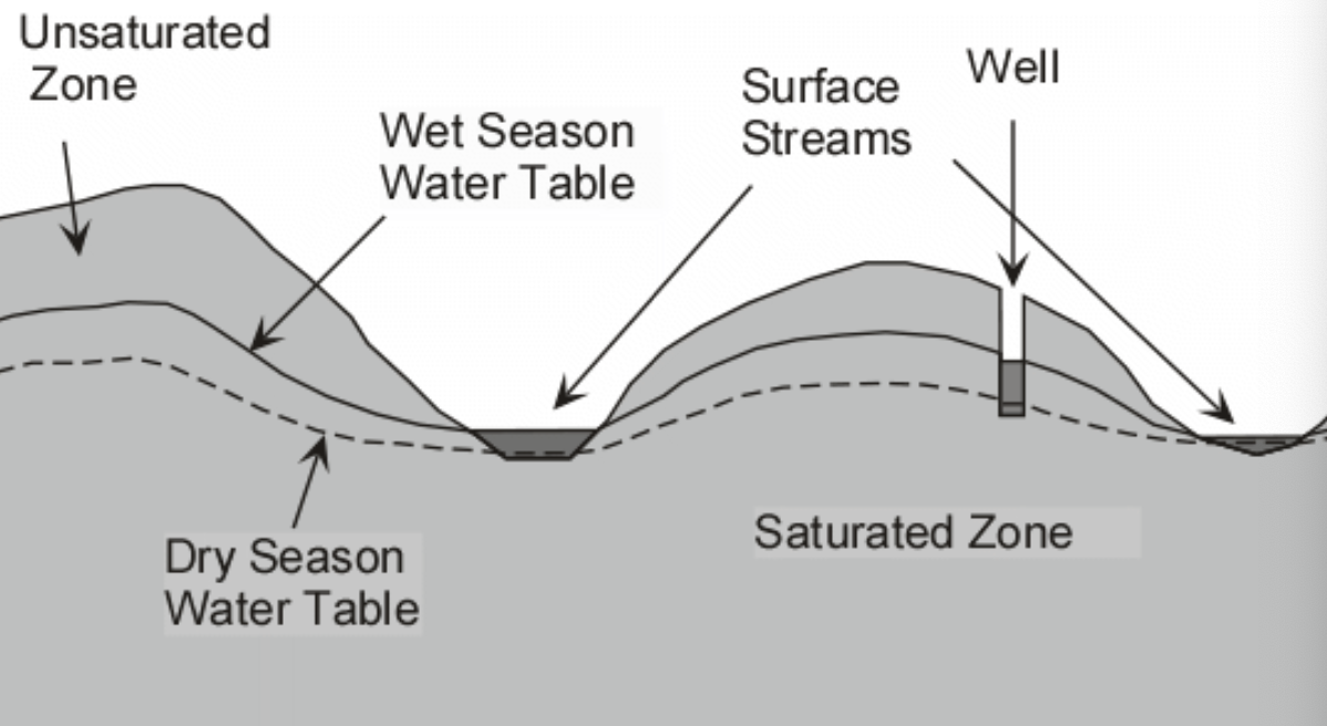
- Groundwater associated terms:
- Porosity
- proportion of void space (holes and/or cracks) in material (soil or rock) where fluids could be stored
- Permeability
- Measure of how easily fluids pass through rocks, sediments, or soils
- Porosity
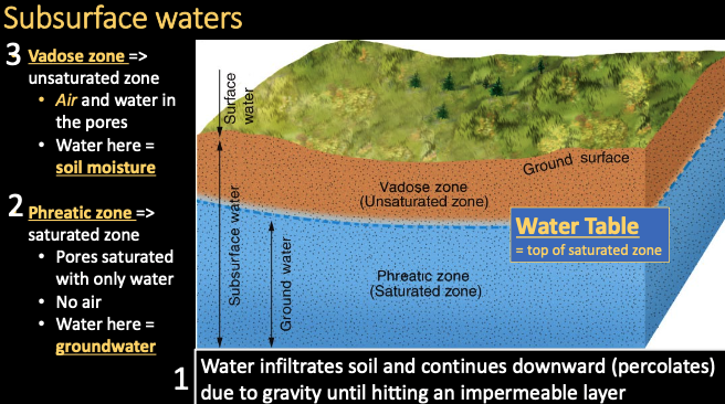
Water table can change height
- With topography
- With seasonal precipitation
- With human-induced extraction
Remember this pic? Might be asked
Water table can intersect ground surface to become surface water:
-
Lake
-
Stream
-
Wetland
-
Spring Groundwater discharge
-
Recharge
- …
-
Aquifer
- rock or soil porous enough to hold a useful amount of water and permeable enough so that water can be transported easily
-
Aquitard
- rock with lots of water but the permeability is too low to be useful for obtaining water
-
Types of aquifers
- Unconfined aquifer
- Confined aquifer
-
Unconfined aquifer
- Directly overlain by permeable materials
- Aquifer is recharged easily
- Water is easily obtained
-
Confined aquifer
- Bounded above and below by aquitards
- Typically takes years to centuries to recharge
- Depleting these is not sustainable
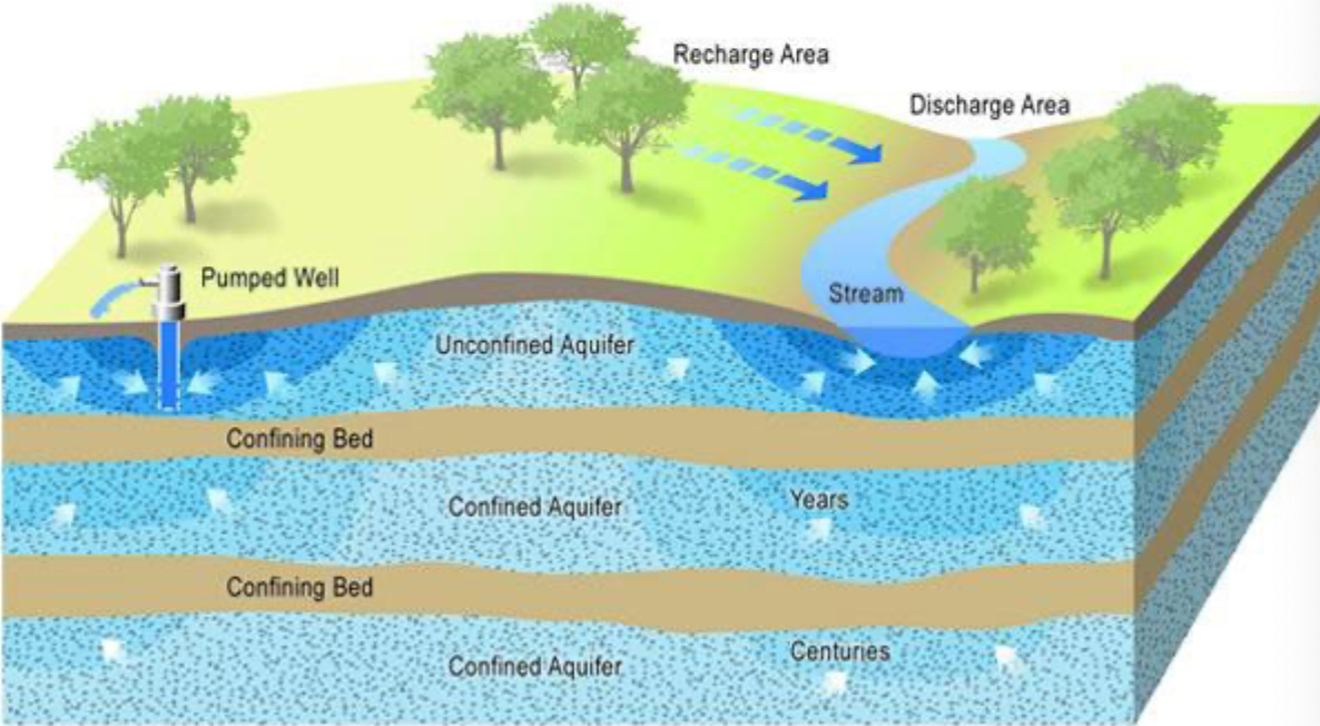
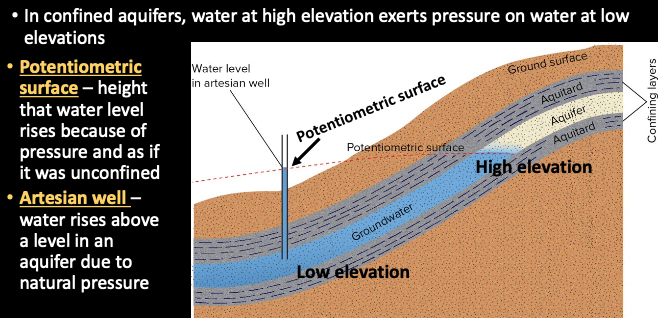
-
Artesian well
- water rises from a well due to natural pressure
-
Impacts if too much water is extracted
- Withdrawal could lead to lowering of the water table
- Withdrawing water/lowering water table leads to compaction of aquifer rocks by weight of overlying rocks
- Saltwater intrusion in coastal areas
-
Karts
- distinctive looking terrain of rocks that have been heavily dissolved by subsurface water
- Underground karts (large voids and cave) ⇒ good to store water (40% of USA’s groundwater-sourced)
-
Sinkholes
- ground collapsing abruptly into a large void in underlying karst
Soil Resources & Erosion
the two types of weathering and how they differ; specific mechanisms of each weathering type; know the soil horizons; general types of soils and general properties; know the special soils (lateritic, wetlands, etc)
- Two types of weathering
- Mechanical weathering
- No chemical change. Physical breakdown of minerals and rocks by mechanical action.
- Breaks it down into smaller pieces
- Processes:
- Freeze-thaw cycle (ice/frost wedging)
- Expansion from unloading
- Salt wedging
- Chemical weathering
- breakdown of rocks and minerals by chemical reactions (decomposition)
- reactions with water, with chemicals dissolved in water (dissolution, hydrolysis), or with gases in the air (oxidation)
- Mechanical weathering
- General types of soils
- O horizon: organic
- A horizon: most weathered mineral mixed with organic matter
- E horizon / Zone of leaching: water infiltrate and organic acids
- B horizon / Zone of accumulation
- C horizon: broken up rock
- Soil properties
- Texture: fragment sizes
- Structure: tendency to form lumps or clods called peds
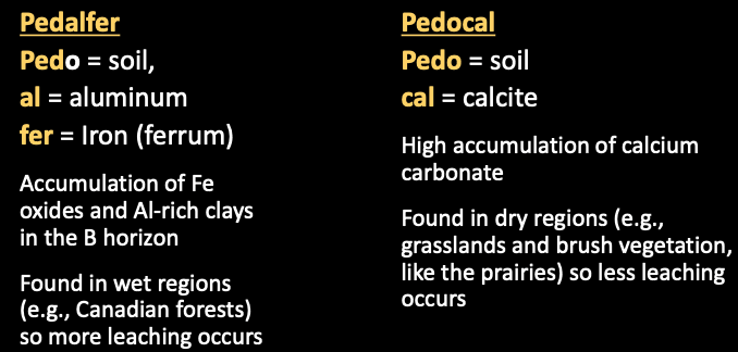
- Special soils (lateritic, wetlands, etc)
- Lateritic soil: Laterite - extreme pedalfer, formed in tropical climates with high temp and heavy rains ⇒ severely leached, bricklike: resist infiltration by water or plant roots
- Wetland soil: highly organic, low in oxygen, and soft. Trap for pollutants, and as flood control. Drained for farmland or development
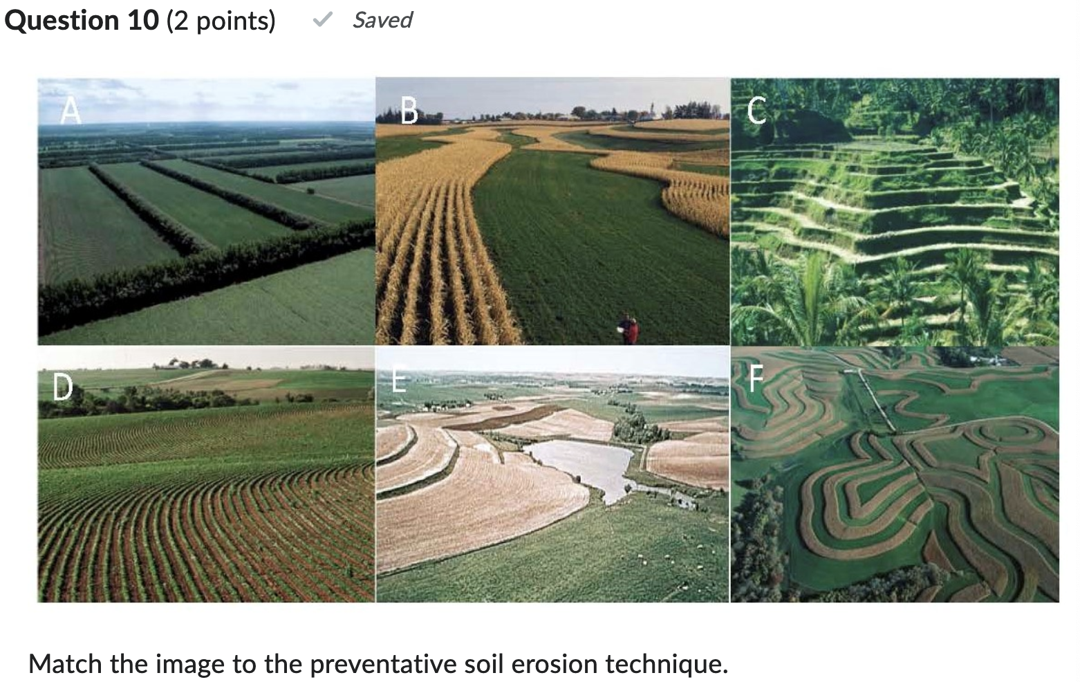
- Soil Erosion
- Contour plowing
- Strip cropping
- Strip cropping + contour plowing
- Plant trees
- Terrace farming
Topics to focus on in Waste/Pollution Module
Waste
different types of waste; different municipal waste methods and specifics about landfills; understand radioactive half-life; how to deal with liquid waste
- Types of waste
- Municipal solid waste
- Industrial solid waste
- Hazardous waste
- Wastewater
- Mining waste is a problem in Canada.
- Over half our waste is from agriculture
- Municipal waste methods:
- Landfills
- Open dumps: easy and cheap, gross, smelly, attracks animals, fire hazards, leach chemicals, erode
- Sanitary Landfills: think of toy story, compacted trash laid down and covered by layer of soil each day. Most common, use valleys, abandoned pits or surface mines. When full, repurposed by covering with think layer. ⛳
- Landfill Gas
- Incinerate
- Release pollutants
- Only combustibles should be burned, like paper and wood
- Ocean dumping
- Compost / Recycle
- household and yard waste
- recycling glass, paper, plastic
- Landfills
- Understand radioactive half-life
- length of time required for half the atoms of that isotope to decay
- How to deal with liquid waste?
- Liquid high-level waste
- Currently stored in cooled underground tanks that leak
- Caverns in low-permeability, unfractured igneous rocks are better option
- Liquid high-level waste
Water Pollution
point vs non-point sources; basics about different types of pollution; eutrophication; biological oxygen demand
- Point vs non-point sources
- Point Sources: pollutant released from one identifiable source. Easier to identify and control than non-point sources
- Nonpoint Sources: diffuse sources coming from a wider area and potentially multiple entry points.
- e.g., fertilizer/pesticide runoff from farms; acid drainage from strip mine; road salt runoff from street
- Types of pollution
- Organic Matter
- Sources:
- Runoff from animal feedlot (major source)
- Discharge from food processing plants
- Human or animal waste
- Algea in pond
- Runoff from municipal streets or highways
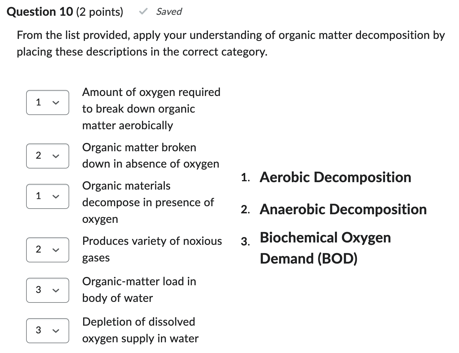
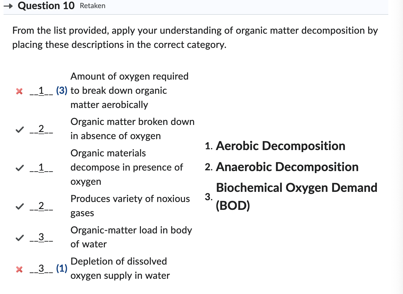
- Organic matter broken down by microbes:
- aerobic decomposition
- anaerobic decomposition
- Biological oxygen demand (BOD): amount of oxygen required to breakdown the organic matter aerobically. The amount of oxygen needed by microorganisms to decompose biological wastes into carbon dioxide, water, and minerals.
- Eutrophication: result of excess nutrients (nitrates, phosphates, sulfates) in water from breakdown of organic matter or direct sources like fertilizer runoff from farms.
- Algae just grows asf, increases BODm but can also be a natural thing
- Sources:
- Agricultural Pollution
- Chemicals in pesticides and fertilizers found in water, fish and sediments
- Industrial Pollution
- Toxic chemicals created
- Inorganic pollutants - Metals
- Arsenic, mercury, copper: think of fish
- Other Inorganic Pollutants
- Chlorine, acid mine drainage, asbestos mine waste
- Organic Pollutants
- Pesticides, oil spills, pharmaceuticals in our water
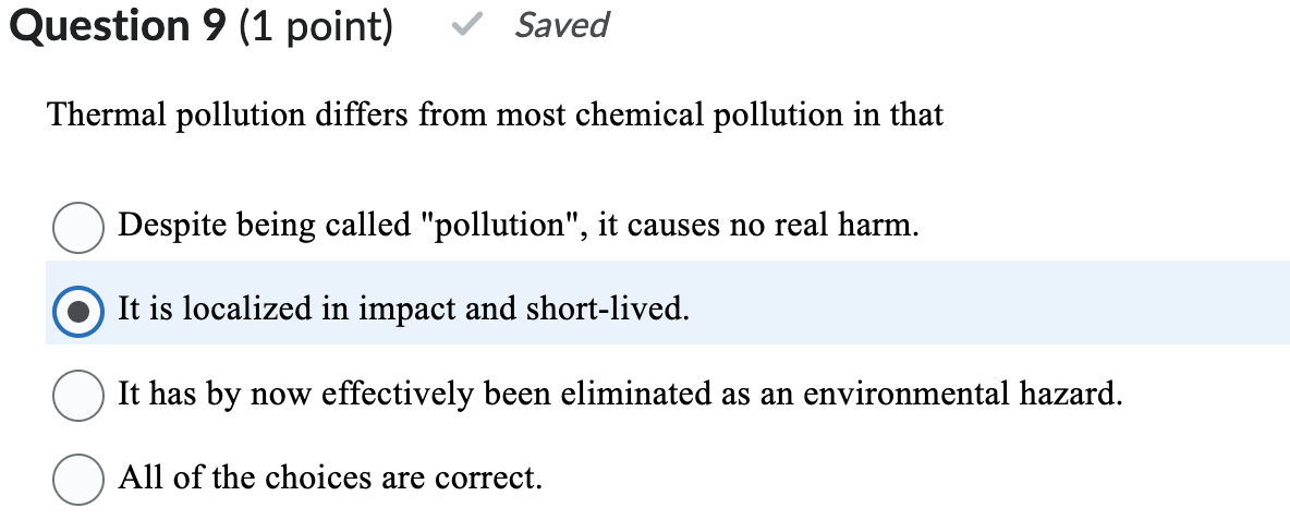
- Thermal Pollution
- Groundwater Pollution
- can be polluted by point or nonpoint souces
- Hard to reverse:
- Containment
- In situ decontamination
- Pump and treat
- Natural process wait
- Organic Matter
Air Pollution
what is in our atmosphere and about how much; what causes acid rain; the different ozone regions of our atmosphere; how weather can impact air pollution
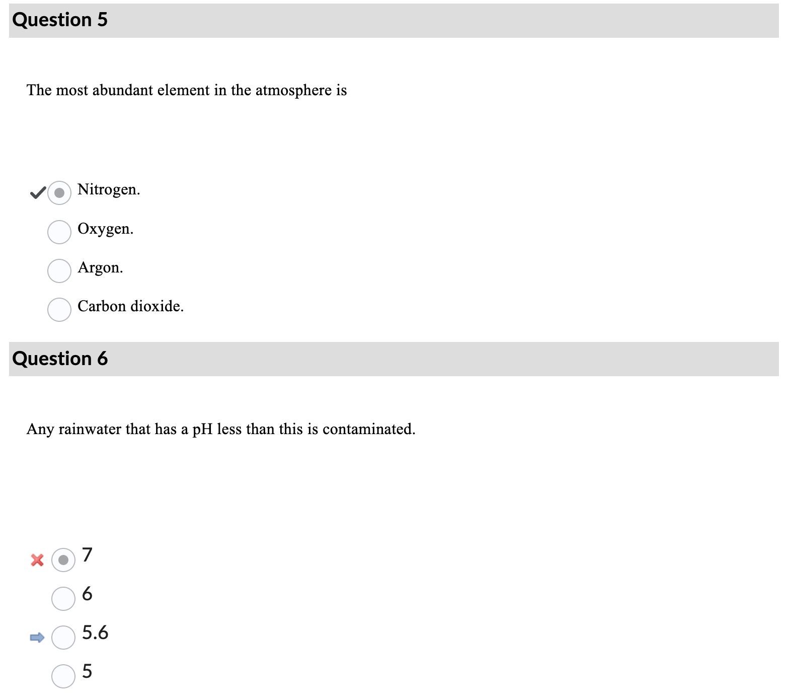
- Atmosphere: Nitrogen (78%), Oxygen (21%), Carbon dioxide (0.04%), Argon (0.93%), Others…
- What causes acid rain?
- mining? nickel?
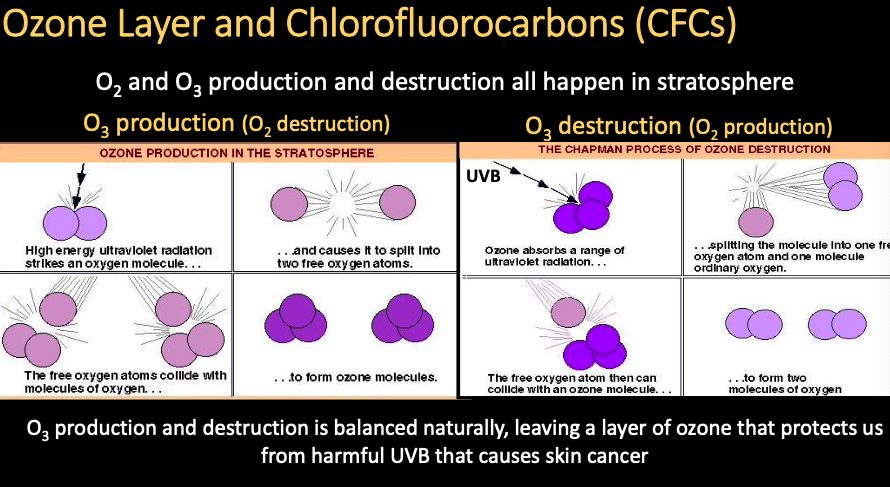
- Different ozone regions in atmosphere?
- in stratosphere is the ozone layer that protects us from UV radiation
- UVA, UVC, UVB
- at ground level (troposphere) is an irritant
- contributes to smog =
- and Smog Ozone
- Ground ozone occurs mostly in northern hemisphere, where cities and industries are more concentrated
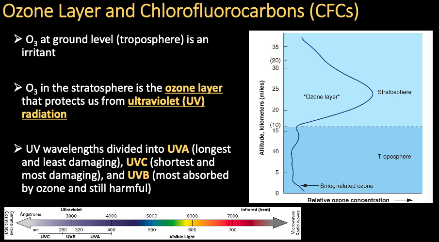
- Ground ozone occurs mostly in northern hemisphere, where cities and industries are more concentrated
- in stratosphere is the ozone layer that protects us from UV radiation
- how weather can impact air pollution?
- Thermal inversion = layer of cool air occurs beneath a layer of warmer air
- Caused the famous london smog
- Certain geographic or topographic settings prone to thermal inversions
- Coastal areas up against mountains
- Valleys in between mountains
- Thermal inversion = layer of cool air occurs beneath a layer of warmer air
Exam 1
Ada’s flashcards: https://quizlet.com/ca/883995616/uw-sci250-flash-cards/?i=3xpj8p&x=1jqt
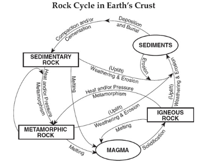
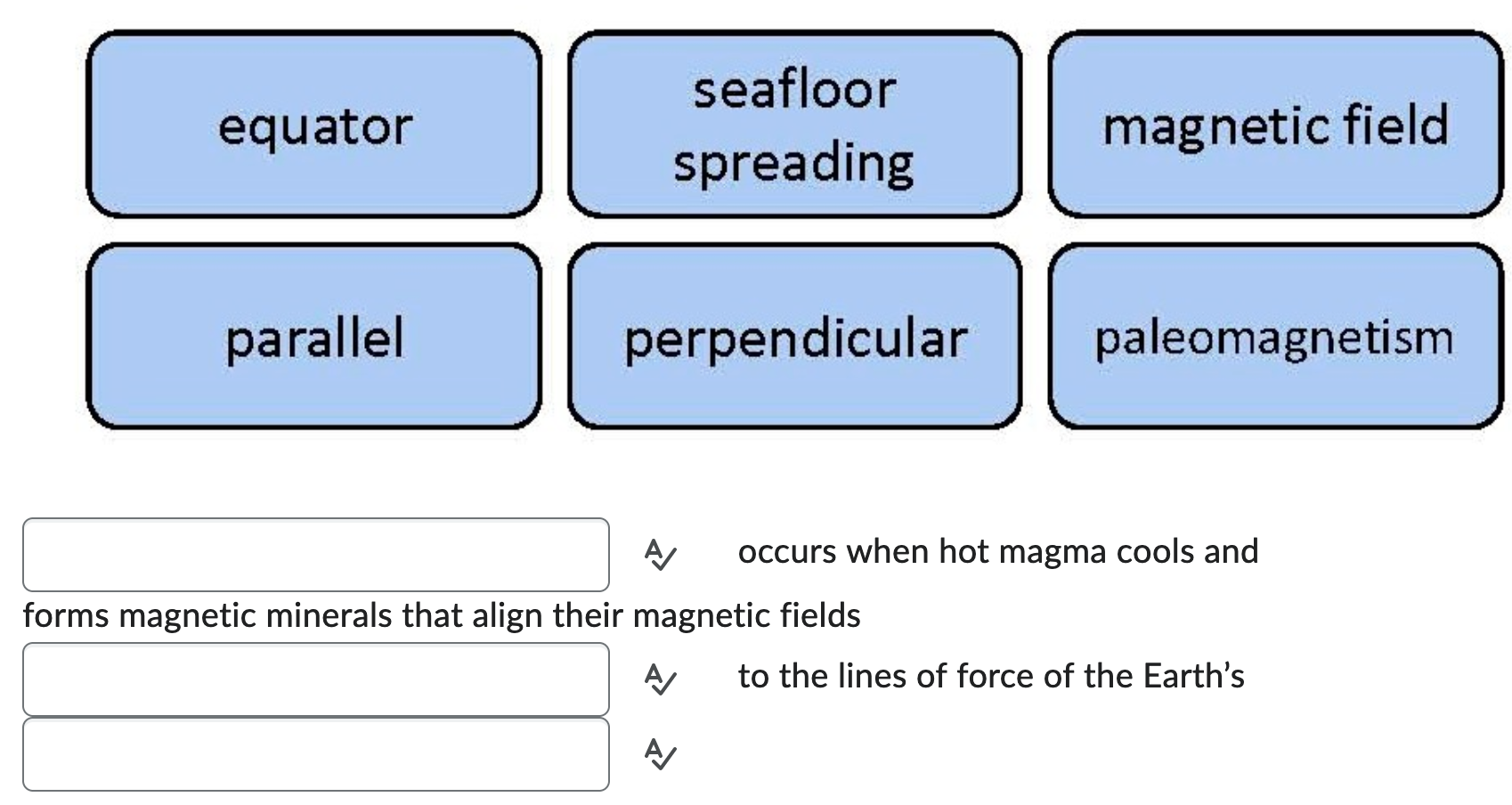
- rock cycle
- Paleomagnetism and seafloor spreading
- ferromagnesian in minerals in magma align with earth’s magnetic field upon cooling and formation of seafloor basalts
- Lithosphere
- Crust and upper mantle;
- acts brittle and elastic
- Asthenosphere
- Only mantle;
- rock flows plastically under high temp and moderately confining pressure
- 3 types of plate boundaries
- divergent, convergent, transform
- Divergent plate boundaries
- Lithospheric plates move apart, causing tensile stress;
- volcanoes and earthquakes common.
- Two types: ocean ridges, continental rifts
- Convergent plate boundaries
- Plates move towards one another.
- Continental + Continental = Mountains.
- Oceanic goes under land, forms mountains and volcanos.
- Oceanic goes under other oceanic.
- Subduction zone
- The region where oceanic plates sink down into the asthenosphere.
- Transform plate boundaries
- Areas where two plates grind past each other resulting in faults such as the San Andreas Fault.
- Earthquakes often occur at fault lines.
- Mantle convection ???
- Some rising magma at spreading centers spreads in upper asthenosphere, dragging overlying lithosphere with it and keeping spreading center open, until dense oceanic crust subducts creates convection cells within mantle.
- Slab pull
- Starts at subduction zone with dense oceanic crust subducting and pulling plate over, keeping spreading center open
- Ridge push
- Starts at topographic highs at spreading center with lithosphere sliding off aided by rising magma pushing off and dragging asthenosphere with it
- Aseismic slip (creep)
- Slow and gradual movement of plates / displacement without significant activity
- Focus / hypocenter
- the point within the earth where an earthquake rupture starts
- Epicenter
- Point on Earth’s surface directly above an earthquake’s focus
- Focal depth
- Depth of focus
- Dip Direction
- Compass direction of agle of rock
- Dip angle
- Angle of rock relative to horizontal
- Strike
- Compass direction bed is sitting
- Strike-slip fault
- Displacement occurs parallel to strike of rock
- Dip-slip fault
- displacement occurs in vertical direction with the dip
- Normal fault
- Side slides down
- Reverse fault
- Side slides up (steep slope)
- Thrust fault
- Low angle reverse fault
- Body wave
- seismic waves that travel through the Earth’s interior
- Surface wave
- On surface of earth (most of damage, slower than body)
- P waves
- Compressional, fastest, through solid, liquid, gas
- S waves
- Shear
- Slower than P waves
- Only through solid
- L waves
- Shear (Love waves)
- R waves
- Ripples (Rayleigh waves)
- Mafic magma
- magma that is silica poor, low viscosity, releases volatiles, high density, high temperature
- Intermediate magma
- Magma with a silica content between 53% and 65% and an overall composition intermediate between mafic and felsic magma
- Felsic magma
- magma with a high silica content and large volume of gas (explosive eruptions)
- Styles of volcanic activity
- fissure eruptions, individual volcano, shield volcanoes, cinder cones, composite volcano (stratovolcano)
- Fissure eruption
- an eruption in which lava is extruded from narrow fractures or cracks in the crust
- Hot spot
- An area where magma from deep within the mantle melts through the crust above it. Middle of plate, not sure why they exist.
- Individual volcanoes
- Along plate boundaries
- Shield volcanoes
- Mafic lavas flow easily and far, not typically eruptive
- Composite / Stratovolcano
- A large, cone-shaped subaerial volcano consisting of alternating layers of lava and tephra
- Lava dome
- A mountain or hill made from highly viscous lava, which plugs the central conduit of volcanoes
- Pyroclastics
- Solid volcanic materials such as ash and rocks
- Pyroclastic flow
- The expulsion of ash, cinders, bombs, and gases during an explosive volcanic eruption
- Lahars
- volcanic mudflows
- Phreatic eruption
- A steam eruption without lava ejection
Lecture 6 - Coastal Zones
- Berm
- Flat part of beach landward on beach face
- Milling / abrasion
- The grinding effect of sand, pebbles, and cobbles propelled by waves
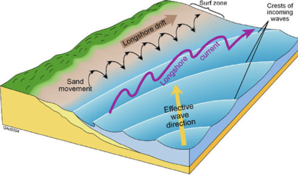
- Littoral drift
- The movement of sand powered by the longshore current. Littoral drift is the name given to the longshore transport of material, under the action of waves and currents
- Storm surge
- Unusual increase in local sea level due to storm
- Active margin
- Active plate boundary with subduction and transform faulting (cliffs, narrow continental shelf)
- Passive margin
- Not an active margin (broad beaches)
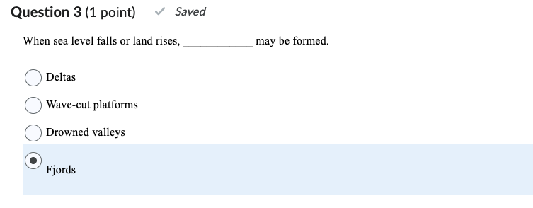
- Emergent coastline
- Coastline that results from either a drop of sea level or an uplifting of the land
- Submergent coastline
- A landform mored when sea level rises or when land sinks
- Groin/jetty
- A wall made of rocks or concrete that is built outward from a beach to reduce erosion (and prevent littoral drift)
- Breakwater
- Island built offshore to moderate wave action on a beach
- deposition behind breakwater
- erosion down current
- breakwater is a permanent structure constructed at a coastal area to protect against tides, currents, waves, and storm surges
- Wave refraction (cliff erosion)
- The bending of waves as it passes from one material to another so that they move nearly parallel to the shoreline.
- Makes headlands particularly vulnerable
- Angle of repose
- The steepest angle at which loose material remains stationary without sliding downslope
Lec 7 - Mass Movements
- Frost wedges (effects of fluids)
- Freezing/thawing cracks in rocks or driving chunks of material apart in soils
- Frost heaving (effects of fluids)
- Freezing/thawing of wet soil loosens soil overall
- Quick clays
- Common in north polar and resulted from rock flour (very fine clay) produced from glacier
- Sensitive clays
- Similar to quick clays but generally form in other locations and from volcanic ash
- Creep
- Slow downslope movement of soil or rock
- Falls
- debris of falls
- Slides
- material moves as cohesive unit along clearly defined surface
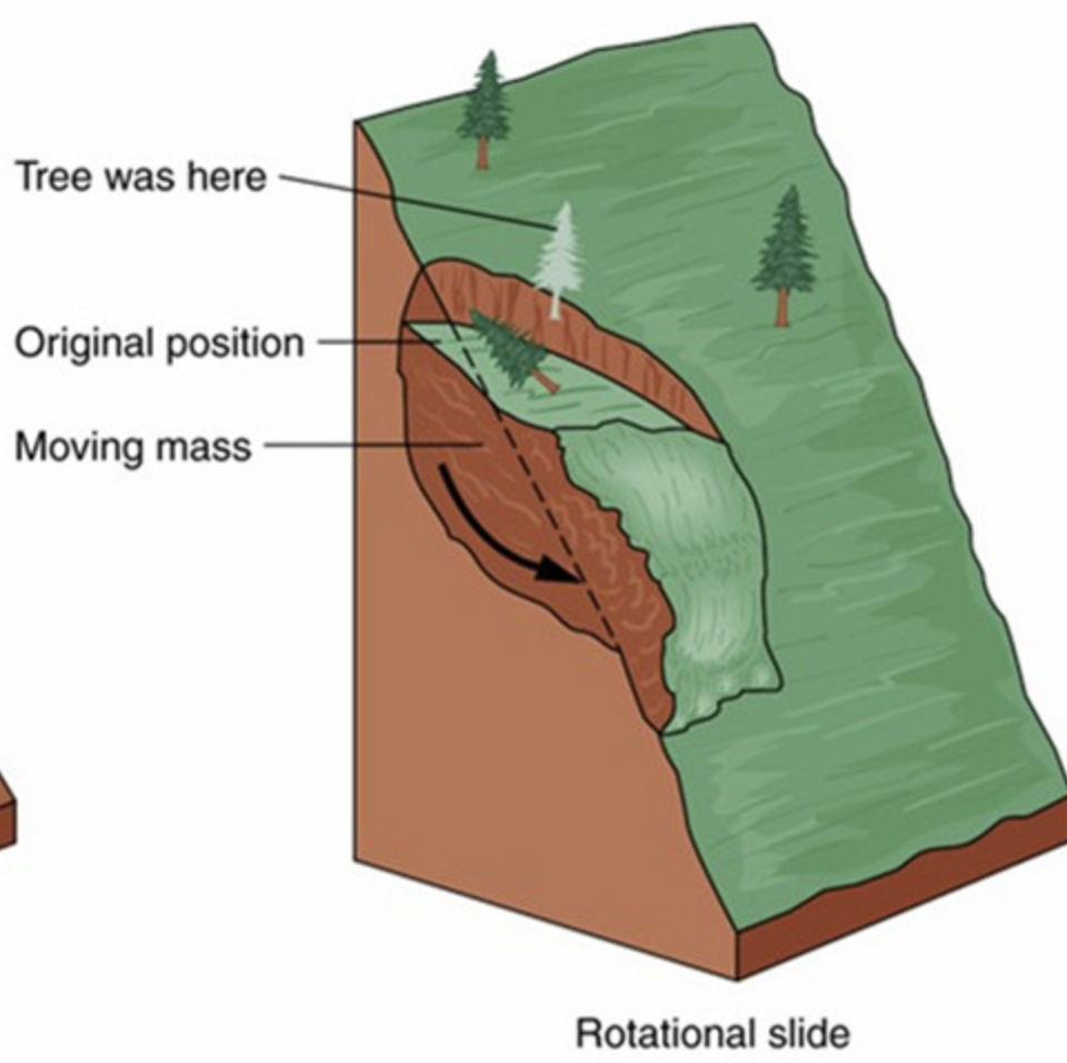
- Slumps
- Downslope accompanied by rotation
- often formation of scarp at top. flow at bottom
- Flow
- chaotic
- earthflow - dry soil
- mudflows - wet soil
Lecture 8 - Streams and Flooding
- Stream
- Any body of flowing water confined within a channel
- Drainage basin
- Region from which stream draws water
- Tributaries
- Streams that feed into other streams, creating a network
- Discharge
- Volume of water flowing past a given point (or through a given cross section) in a specified length of time
- Bed load
- sediment that is carried by a stream along the bottom of its channel
- Suspend load
- tiny solid grains carried along by a stream without settling to the floor of the channel
- Dissolved load
- materials dissolved in water
- Stream load
- Bed load + suspended load + dissolved load
- Base level
- lowest elevation to which the stream can erode
- Sediment Sorting
- stream velocity dictates sediment sorting
- sediments are commonly well sorted by size and density
- Delta
- fan-shaped pile of sediment in still waters created by stream
- Alluvial fan
- fan-shaped sediment in large of stream/region between mountains and plain formed by small tributary stream
- Braided streams
- water braiding/flowing around obstacles for deposition
- Meanders (channels)
- bends in streams formed by flowing water
- Point bar (channels)
- deposit of sediment build up by a river on the inside ben of a meander
- Floodplain
- where streams spill over during floods
- Scar
- remnants of meanders
- Oxbow
- a meander that has been cut off from the river by rapidly flowing water creating new path
- Upstream floods (flood characteristics)
- floods that affect only small, localized areas
- Downstream floods (flood characteristics)
- floods that affect large stream systems and large drainage basins
- Restrictive Zoning (reducing flood hazards)
- careful mapping and placing features strategically
- Retention pond (reducing flood hazards)
- build structure to trap some surface water runoff
- Diversion channel (reducing flood hazards)
- redirects some water into other safer places when levels rise
- Channelization (reducing flood hazards)
- various modifications of the stream channel itself to increase velocity of water flow, the volume of the channel, or both
- Levees
- ancient technique of raising banks along a stream channel
Lecture 9 - Climate - Past, Present and Future
- Greenhouse Gases (GHG)
- includes wter vapor (most abundant), CO_2, CH4, N2
- Thermohaline circulation
- an oceanic circulation pattern that drives the mixing of surface water and deep water
- La Nina
- El Nino
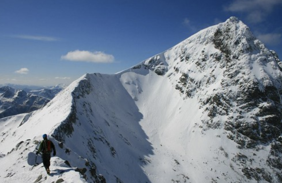
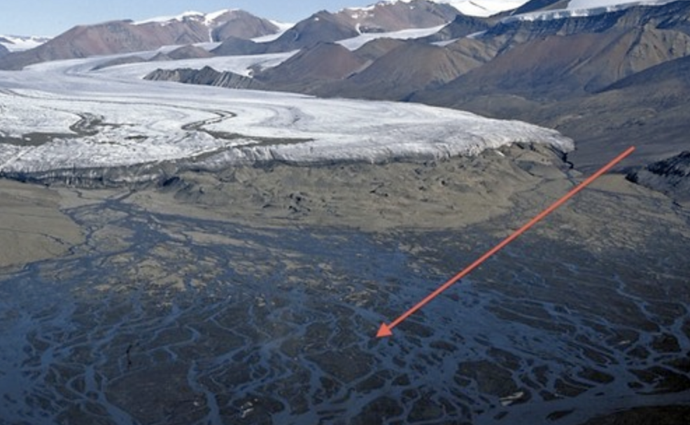
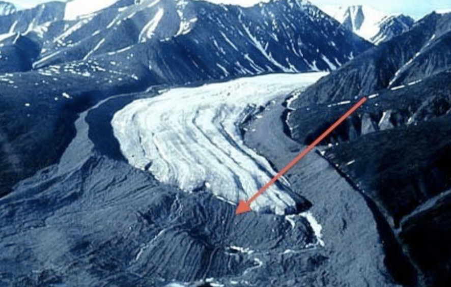
Lecture 10 - Glaciers and Deserts
- Firn
- snow that survives > 1 winter
- recrystallized into a material denser than snow because it has less air
- Calving
- process by which a block of a glacier breaks off and falls into the sea to form an iceberg
- glacier that encounters water experience calving
- Ablation
- process which glacial ice is lost
- Plucking (glacial erosion)
- process by which a glacier picks up rocks as it flows over the land
- Cirque
- a bowl shaped basin carved by a glacier (erosional)
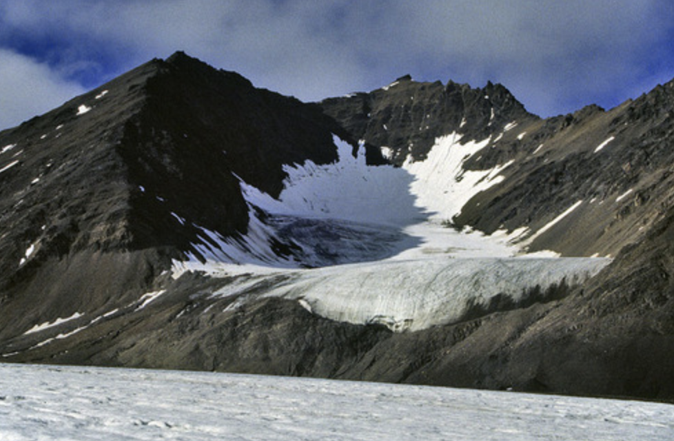
- Arete
- sharp edge between adjacent glaciers
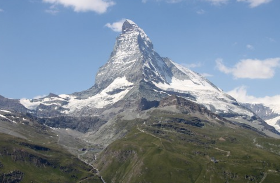
- Horn
- single peak from erosion of several glacier
- Till (glacial deposition)
- the sediments deposited directly by a glacier
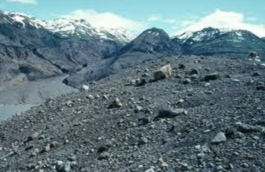
- Outwash (glacial deposition)
- till transported by meltwater and dumped somewhere else
- Moraine (glacial deposition)
- a ridge formed by the till deposited at the edge of a glacier
- Ventifacts (wind erosion)
- rocks shaped by the wind blown sediments
- Deflation (wind erosion)
- removal of loose (fined-grained) sediment by wind, leaves coarse behind
- Desert pavement
- a layer of coarse pebbles and gravel created when wind removed the finer material
- Loess
- deposit of windblown silt
Quizzes
Quiz 2 Plate Tectonics and Earthquakes
- The astenosphere is a weak, locally partly molten layer over which lithospheric plates can move?
- True
- Plate boundaries were originally located by a French graduate student who plotted the location of all earthquakes and volcanic eruptions world-wide on a map?
- True
- At a convergent plate boundary,
- Sea floor is produced
- High mountains may be built during continent-continent collision
- There are very few earthquakes
- All of the choices are correct
- According to plate-tectonic theory, plates of rigid, elastic ___ move over a weak plastic layer below
- Lithosphere
- Astenosphere
- Mantle
- Core
- NO IDEA WHAT
- P waves can travel through solids only; S waves can travel through both liquids and solids
- False
- The moment magnitude scale may be a better indicator of earthquake severity especially for large earthquakes and those occurring outside of California, where the Richter scale was developed.
- True
- Liquefaction is
- Flooding of coastal areas due to tectonic subsidence
- A quicksand-like conditions arising in some we soils during earthquakes
- Flooding caused by tsunamis
- Flooding caused by dam failure resulting from an earthquake
- In a fault when the displacement is horizontal then the type of fault is called
- Dip-slip fault
- Normal fault
- Reverse fault
- Strike-slip fault
- Level V
Quiz 3 - Volcanoes
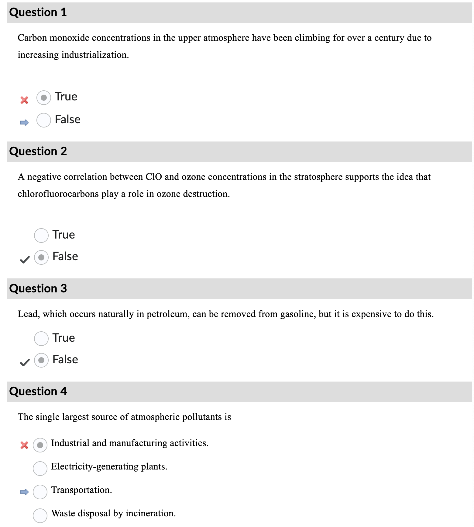
- The so-called Ring of Fire rimming the Pacific Ocean is really a ring of subduction zones. True or false? - True - The Ring of Fire is indeed a horseshoe-shaped zone encircling the Pacific Ocean, known for its high levels of seismic and volcanic activity. It’s characterized by a series of subduction zones where tectonic plates converge, leading to earthquakes, volcanic eruptions, and the formation of mountain ranges.
- Of the following: various sulfur gases, hydrochloric acid, and carbon monoxide, only carbon monoxide is poisonous.
- False
- While carbon monoxide is indeed poisonous, both sulfur gases (such as sulfur dioxide and hydrogen sulfide) and hydrochloric acid can also be harmful to human health. Sulfur gases can cause respiratory issues and irritation, while hydrochloric acid is corrosive and can cause burns if it comes into contact with skin or mucous membranes.
- People can be killed by poisonous gases emitted by a volcano even before they realize that they are in danger.
- True. Volcanic eruptions can release various toxic gases, such as sulfur dioxide, carbon dioxide, hydrogen sulfide, and others, which can be deadly even in small concentrations. These gases are often odorless and colorless, making it difficult for people to detect their presence until it’s too late. In some cases, these gases can accumulate in low-lying areas or valleys, posing a significant risk to nearby communities.
- Active periods in a volcano’s history :
- “May occur at intervals of hundreds or thousands of years, with quiet periods in between.”
- A caldera is
- ”A topographically low area that results from the collapse of a volcano after its magma chamber empties or removal of the top of a volcano during an explosive eruption.” Calderas are indeed formed by the collapse of a volcano’s summit or by the emptying of the magma chamber beneath it, resulting in a large, basin-like depression. They can be associated with various types of volcanic activity, not just basaltic volcanism, and can persist for long periods of time, with ancient calderas existing as evidence of past volcanic activity.
- The Pacific Ring of Fire is :
- “Volcanic activity related to subduction zones and spreading zones rimming the Pacific Ocean basin.” The Pacific Ring of Fire is characterized by volcanic activity associated with subduction zones, where tectonic plates converge and one plate is forced beneath another, as well as spreading zones, where plates are moving apart. This results in a ring-shaped zone of intense volcanic and seismic activity around the Pacific Ocean basin.
- Difference between shield volcano, cinder cone volcano and composite volcano
- eruption from single vent: cinder cone volcano
- flat and low in relation to diameter: shield volcano
- Built-up gas pressure in rising magma released suddenly: composite volcano
- Highly explosive eruptions: composite volcano
- Formed from particles and blobs of congealed lava: cinder cone volcano
- Built over time by numerous flows: shield volcano
- Typically steep-sided and symmetrical: composite volcano
- Formed by low viscosity: shield volcano
- Mix of lava and pyroclastics: composite
Got this question wrong
Quiz 4 -
As a wave approaches land, the end farthest to shore encounters the seafloor first, forcing the wave to slow down while the other end travels at its original speed. This causes a difference in velocity which in turn causes the wave to bend or refract toward shore. Breaking waves push water up the beach, creating a zigzagging path as the water flows back into the surf zone. This is important as it causes sediment to drift parallel to shore in a process known as littoral drift. Wave refraction also forces water to flow parallel to shore in what is known as a longshore current.

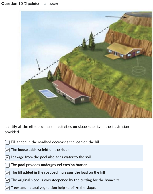
- Trees and natural vegetation apparently don’t help stabilize the slope in this image
Quiz 5:

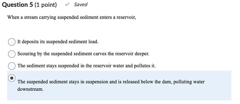 Wrong: Correct answer is It deposits its suspended sediment load.
I got Question 6 wrong…
Quiz 6 - Forgot to do it…
Quiz 7 - Mineral/Rocks Resources & Fossil Fuels

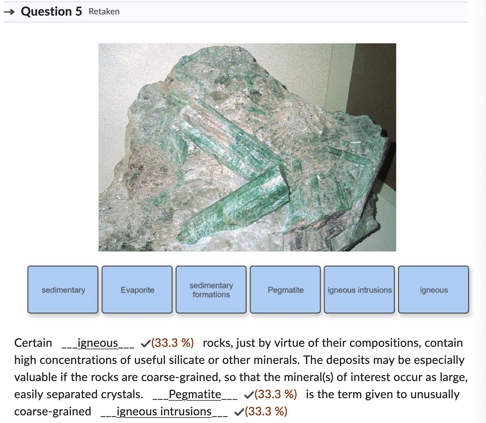
Feedback: Certain igneous rocks, just by virtue of their compositions, contain high concentrations of useful silicate or other minerals. The deposits may be especially valuable if the rocks are coarse-grained, so that the mineral(s) of interest occur as large, easily separated crystals. Pegmatite is the term given to unusually coarse-grained igneous intrusions.
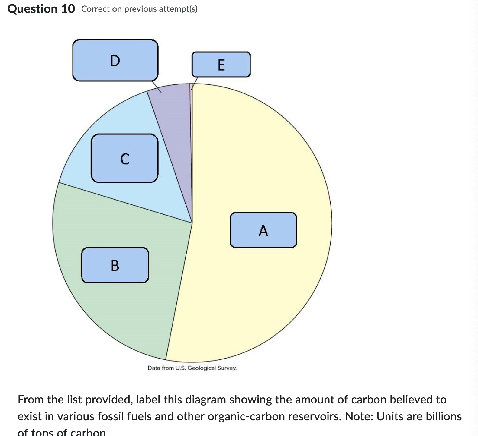
Feedback: The U.S. Geological Survey has estimated that the amount of carbon found in gas hydrates may be twice that in all known fossil fuels on earth. Just how to tap gas hydrates safely for their energy is not yet clear. In arctic regions, the hydrates are stabilized by the low temperature. If these arctic sediments are warmed enough by the continued warming of the Arctic to break down some of the hydrates, or if they are disturbed in the course of extracting methane, methane gas would be released into the atmosphere, which would further increase greenhouse-effect heating.
Quiz 8 - Alternative Energy
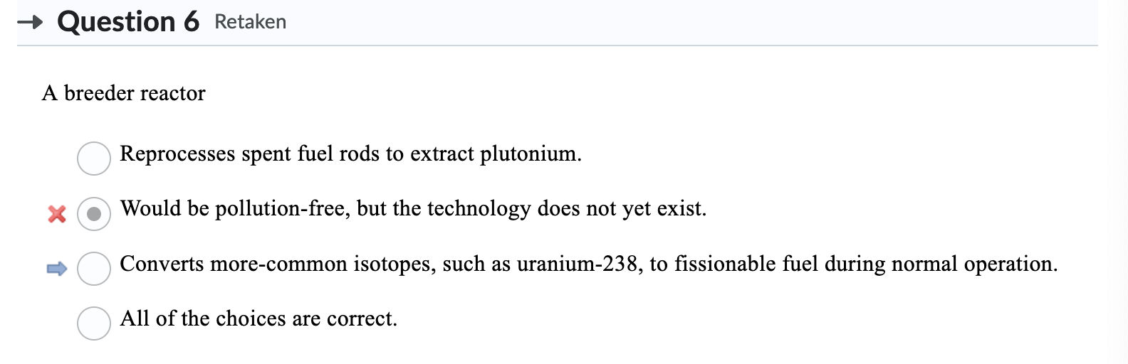
- What’s the correct answer? Correct answer is converts more-common isotopes, such as uranium-238, to fissionable fuel during normal operation
- No idea what the correct answer is. nvm correct answer is the following:
Quiz 9 - Water Resources & Erosion/Soil Resources
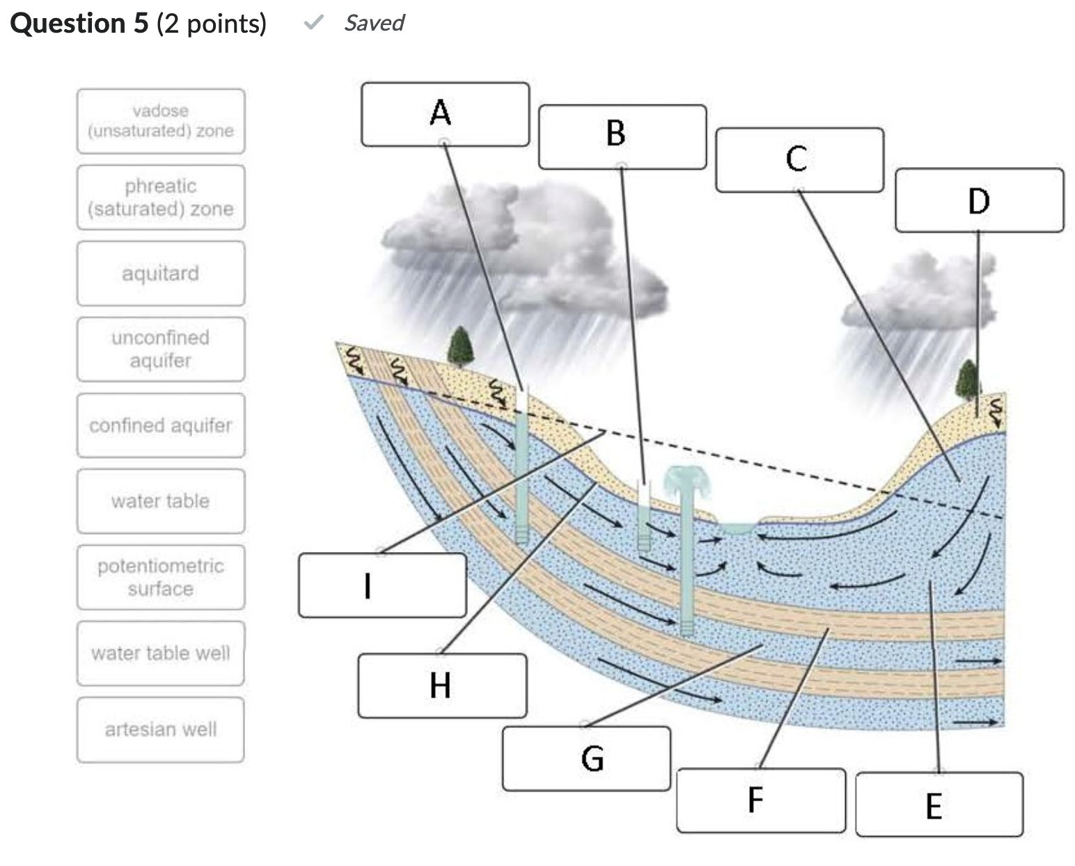
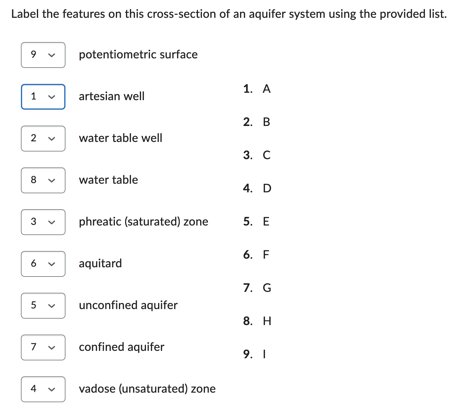
Feedback: An unconfined aquifer is open to the surface environment and has a water table that marks the top of the saturated zone, or phreatic zone. A confined aquifer has an overlying aquitard that limits the vertical movement of water, causing the aquifer to become pressurized. When a well penetrates an aquitard, water rises to the potentiometric surface, which represents the amount of pressure within a confined aquifer. Above the saturated zone is rock or soil in which the pore spaces are filled partly with water, partly with air: the unsaturated zone, or vadose zone.
- mechanical weathering and chemical weathering
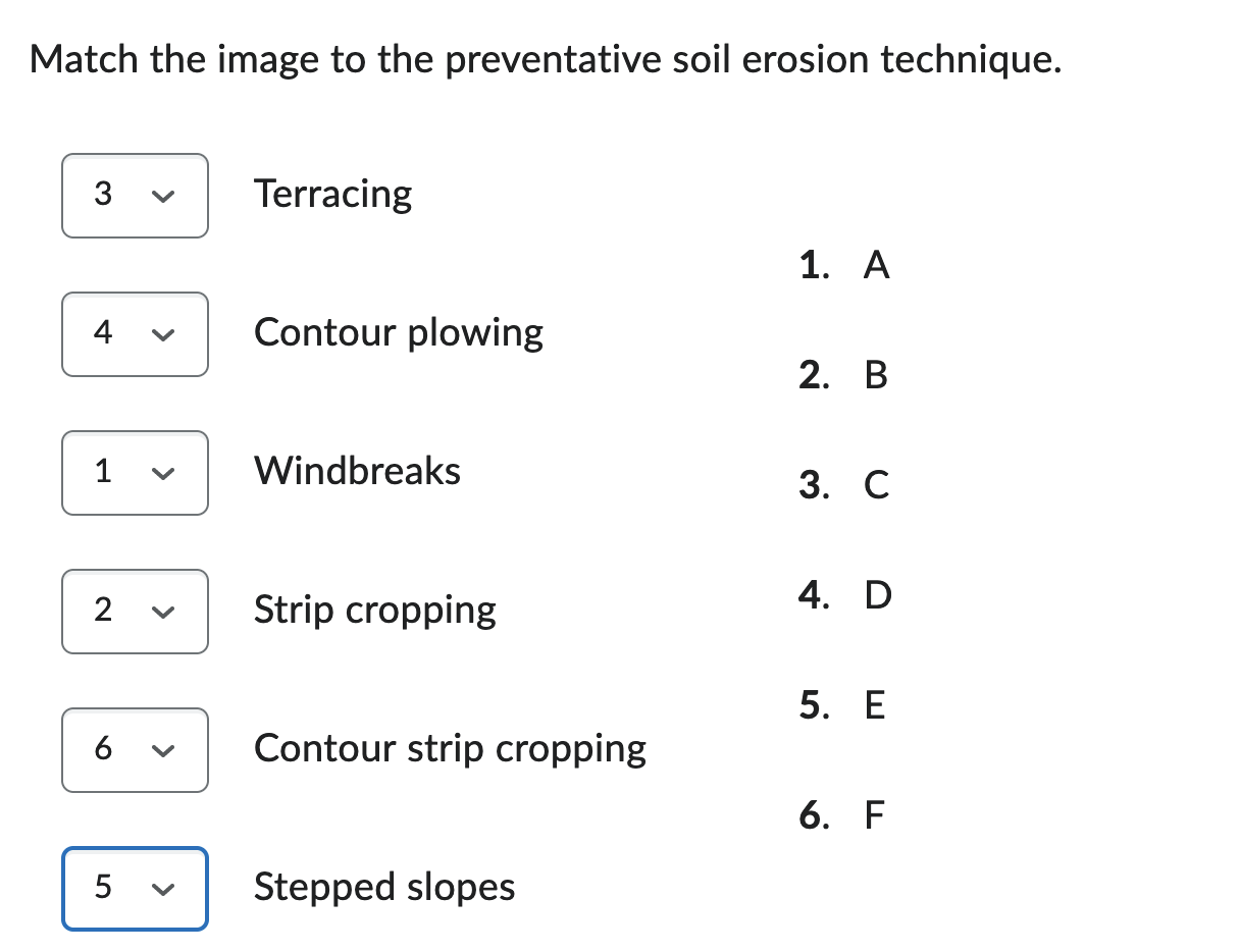
All correct. Feedback: Wind can be slowed down by planting hedges or rows of trees as windbreaks along field borders or in rows perpendicular to the dominant wind direction or by erecting low fences, like snow fences, similarly arrayed. This does not altogether stop soil movement, as shown by the ridges of soil that sometimes pile up along the windbreaks. However, it does reduce the distance over which soil is transported, and some of the soil caught along the windbreaks can be redistributed over the fields. Strip cropping, alternating crops of different heights, slows near-ground wind by making the land surface more irregular. Combining strip cropping and contouring may help reduce both wind as with strip cropping and surface runoff may be slowed on moderate slopes by contouring plow lines with the slopes of the hillside. Terracing reduces the risks of soil erosion, creep or mass wasting in response to saturated or heavy wet soil with minimal root structure to hold the soil in place.
Quiz 10 - Waste Disposal & Water Pollution
Question 5
Feedback:
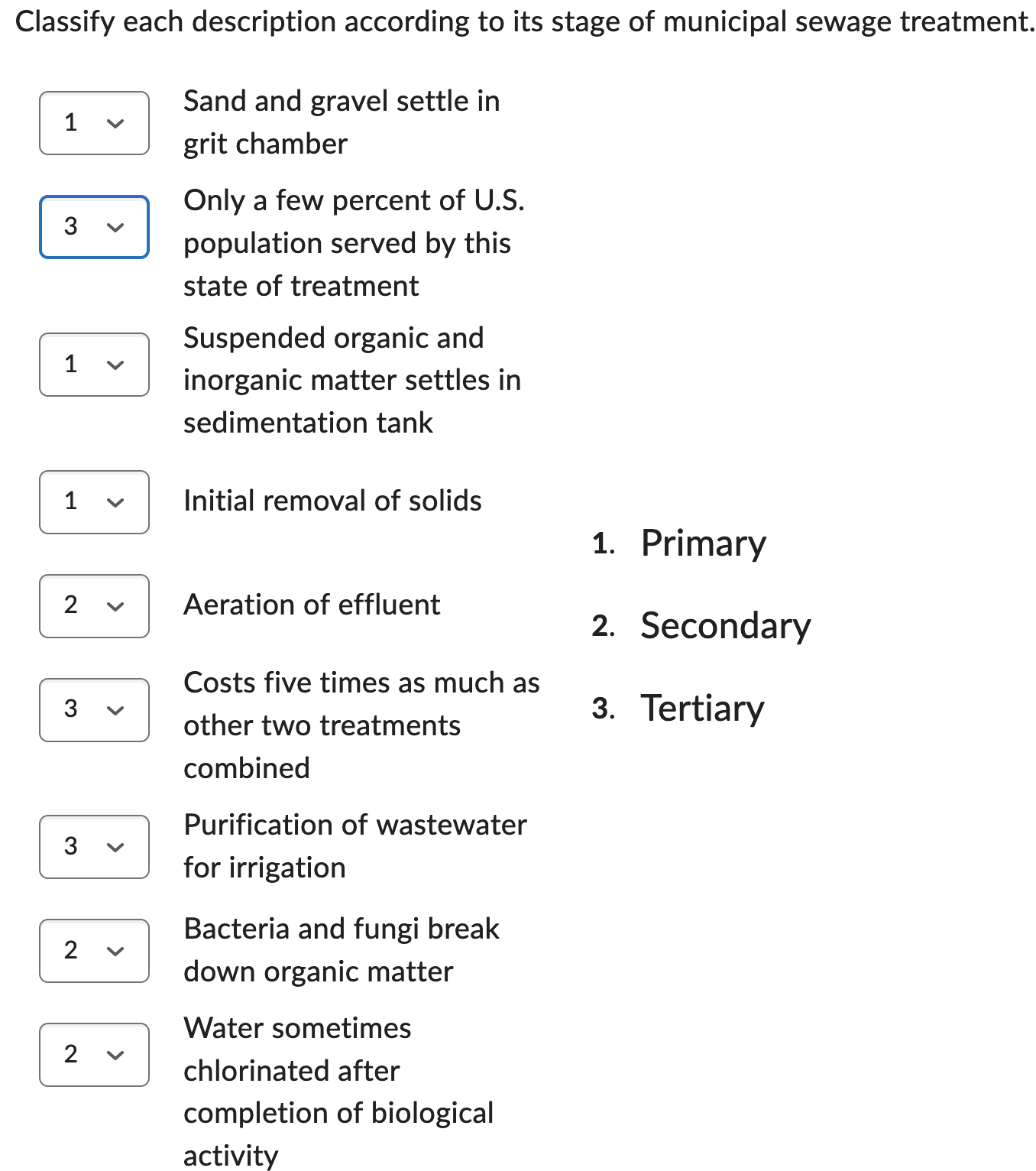
- Primary treatment is usually physical processing only, involving removal of solids, including inorganic trash, fine sediment, and so on, that has been picked up by the wastewater. Sand and gravel then settle in the grit chamber. The flow is slowed, and suspended organic and inorganic matter settles into the bottom of the sedimentation tank.
- Secondary treatment of the remaining liquid is mainly biological. The effluent from primary treatment is aerated, and bacteria and fungi act on the dissolved and suspended organic matter to break it down. The treated sewage passes through another settling tank to remove solids, which now contain the useful microorganisms, too. This sludge can be cycled back to mix with fresh input water and air to continue the breakdown process. Sometimes, the water is also chlorinated to disinfect it when biological activity is completed.
- Tertiary treatment can render wastewater for irrigation or landscape watering, industrial cooling, or water recharge. Such thorough tertiary wastewater treatment may cost up to five times what primary and secondary treatment together do. Only a few percent of the U.S. population is served by systems undertaking tertiary sewage treatment.
- This is wrong? What’s the right answer??
Feedback:
- In time, organic matter in water is broken down by microorganisms, especially bacteria, just as in a landfill. If there is ample oxygen in the water, aerobic decomposition occurs, consuming oxygen, facilitated by aerobic organisms. This depletes the dissolved oxygen supply in the water. Eventually, so much of the oxygen may be used up that further breakdown must proceed by anaerobic decomposition (without oxygen). Anaerobic decay produces a variety of noxious gases, including hydrogen sulfide (), the toxic gas that smells like rotten eggs.
- The organic-matter load in a body of water is described by a parameter known as biochemical oxygen demand, or BOD for short. The BOD of a system is a measure of the amount of oxygen required to break down the organic matter aerobically.
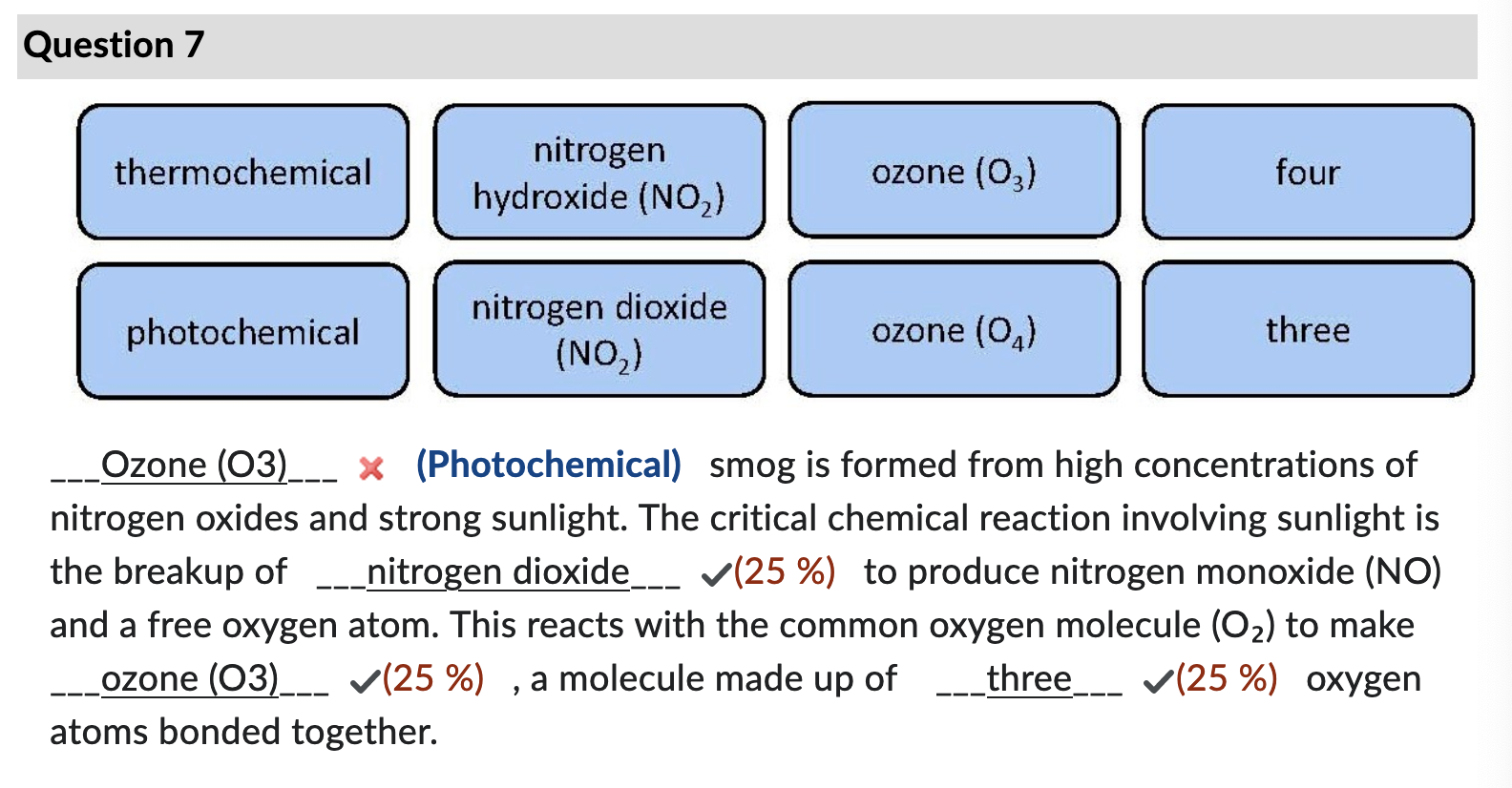
Quiz 11 - Air pollution
Feedback: Key factors in the formation of photochemical smog are high concentrations of nitrogen oxides and strong sunlight. Dozens of chemical reactions may be involved, but the critical one involving sunlight is the breakup of nitrogen dioxide () to produce nitrogen monoxide () and a free oxygen atom, which reacts with the common oxygen molecule () to make ozone, a somewhat unusual molecule made up of three oxygen atoms bonded together.