Glaciers and Deserts
Why study glaciers, ice, wind, and deserts in the same chapter?
- All related to solar heat
- It drives evaporation precipitation and glaciers
- Differential heating between land and water winds
- Seasonal temperatures, wind and climate deserts
- Water, ice, and wind are all agents of change on Earth’s surface
Ice and Glaciers
Formation of Glaciers
-
Formation of a glacier occurs in a region where snow will remain year round
- Snowfall >> Melting
- High latitudes or high elevations
- North-facing slopes in Northern Hemisphere and South-facing in Southern are best
-
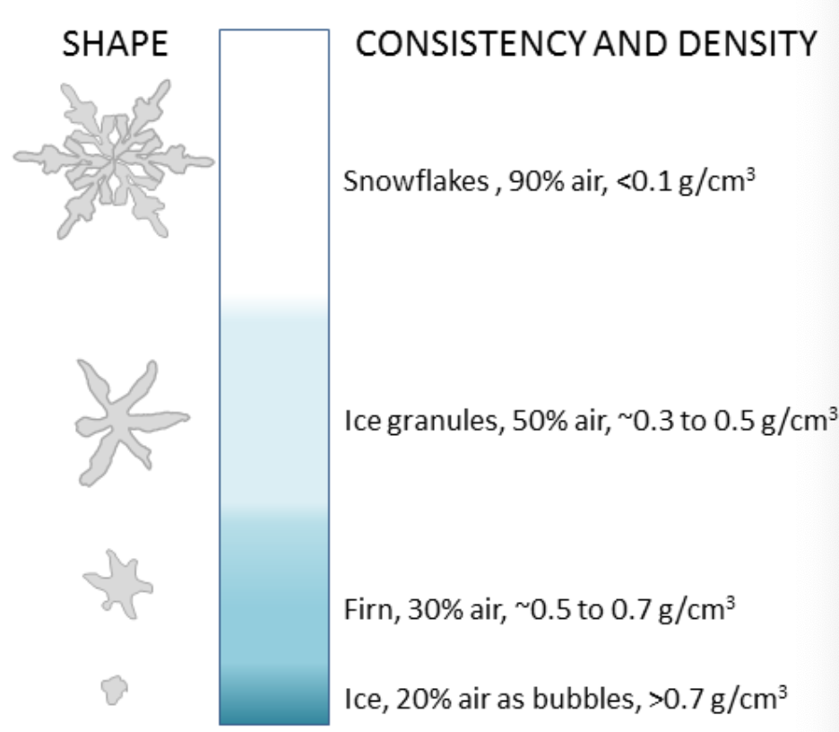
From snow to glacial ice depends on compaction of snow over multiple seasons, reduction in air volume, and increase in density
-
Firn: snow that survives at least one winter; recrystallized into a material denser than snow because it has less air
-
Glacier: mass of ice moving under its own weight due to gravity
- Heat from the sun is generally constant (but not distributed uniformly across the earth over time) locations of glacirs
- Climatic factors may influence the global radiation budget, which impacts extents of glaciers and whether they can exist at all
- Global cooling: ice will accumulate and build ice sheets and glaciers
- Global warming: ice sheet retreat and glaciers get smaller
- Factors that change climate: composition of the atmosphere (, , water vapor), pollution or particles suspended in the atmosphere, abnormal heat retention (or loss) from the oceans
Types of Glaciers
Two types based on size and occurrence
- Alpine Glaciers
- Also known as mountain or valley glaciers
- Occur at high altitude (cooler temperatures)
- Most numerous globally (70,000 - 200,000)
- Continental Glaciers
- Also known as ice caps or ice sheets
- Occur near the poles (over land)
- Larger, thicker (up to 1 km of ice), rarer
- Contain far more ice than all Alpine glaciers
- Greenland and Antarctic ice sheets
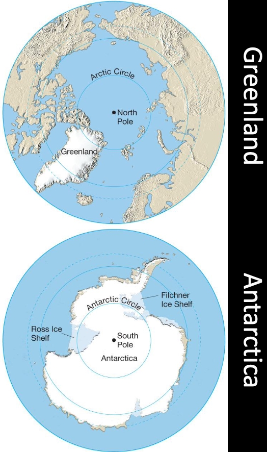
Ice Sheets
- Antartica: an ice sheet averaging 2,160 m thick and reaching a maximum thickness of about 4km nearly covers almost 14,000,000 of Antartica
- of all freshwater held here
- of land not covered in ice (basically ice then bruh)
- Arctic: the continental glacier in Greenland covers about 1,700,000 with a maximum thickness of about 3km
- of land not covered in ice
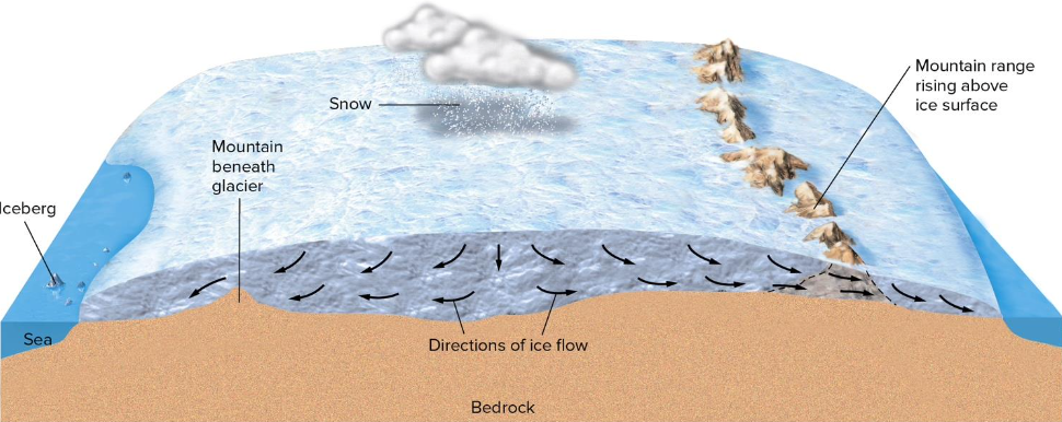
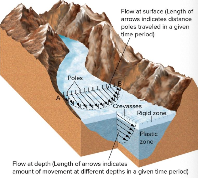
Movement of Glaciers
- Glaciers flow as plastic ice masses and at different rates; overall movement is down slope
- Movement is slow when in contact with land and scarping the valley walls, either at the base or on sides
- Movement is faster near surface and in middle
- Net flow is downslope relative to underlying bedrock or the glacier surface when underlain by mountains
- Meltwater helps it flow often
Glacier movement has a terminus (it ends)
- Glaciers that encounter water will experience calving icebergs
- If temperatures at terminus are warm, then melting or evaporation occurs
- Ablation: processes by which glacial ice is lost
- Equilibrium line: no gain or loss; Above snow accumulates, below ablation
- Movement is slow and steady (10s m/y); surges are possible (10s of m/d).
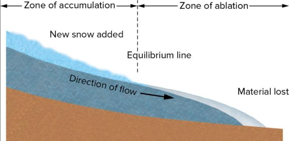
- Advance: glacier becomes thicker and longer (accumulation > ablation)
- Retreat: ablation > accumulation
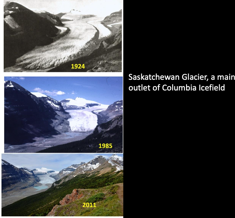
- Some glaciers are advancing but most Alpine glaciers retreating
- Greenland getting thicker in middle and melting more on edges Net loss of ice
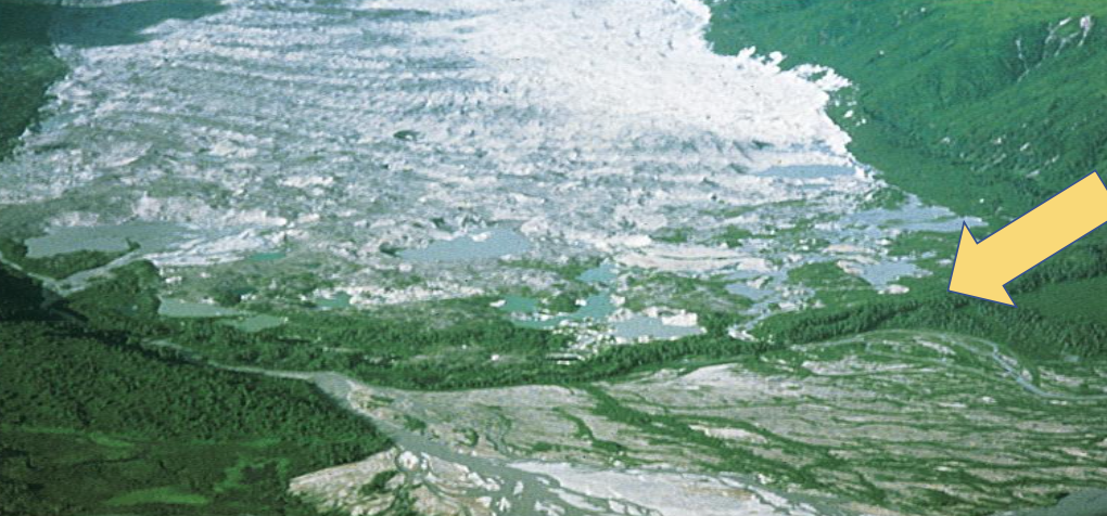
Glacial Erosion
- Glaciers leave evidence of their former presence
- U-shaped valley Rocky Mountains in Colorado
- Finger Lakes, New York, USA
- Striations: rocks frozen into ice grinding along bedrock below
- Abrasion: general erosion by scraping of ice or sediment
- Plucking: Water helps the base of glacier freeze onto rock below and when glacier continues it will pluck/tear off bits of rock its frozen to
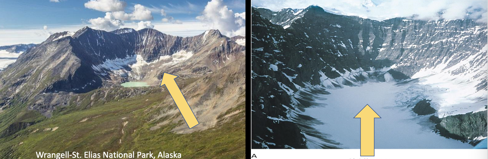
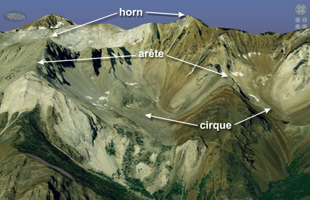
- Cirque: bowl-shaped depression as a result of plucking at the head of the glacier
-
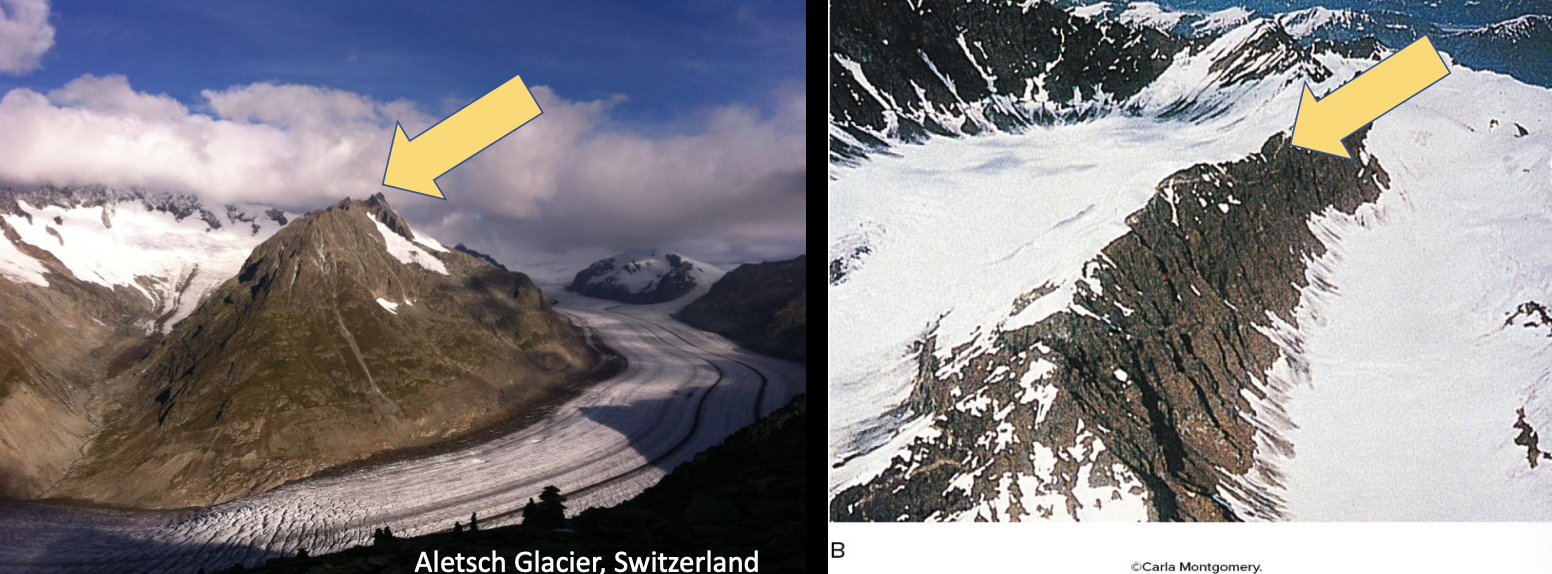
Arête: sharp edge between adjacent glaciers
-
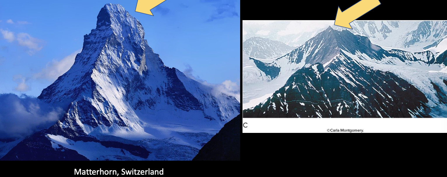
Horn: single peak resulting from erosion of several glaciers
Glacial Deposition
-
All the sediment and rock debris eroded by the glacier tends to be carried with the glacier and deposited when the glacier melts/evaporates
-
Till: sediment deposited directly from the ice
- Till is angular and poorly sorted
-
Outwash: till that is transported by meltwater and deposited elsewhere
-
Glacial drift: ‘A general term applied to all rock material (clay, silt, sand, gravel, boulders) transported by a glacier and deposited directly by or from the ice, or by running water emanating from a glacier’. Till and outwash are varieties of glacial drift.
-
Moraine: landform made of till; different types of moraines exist
- End moraine: ridge of sediment at the nose of the glacier added to repeatedly by the annual advances and retreats of a glacier
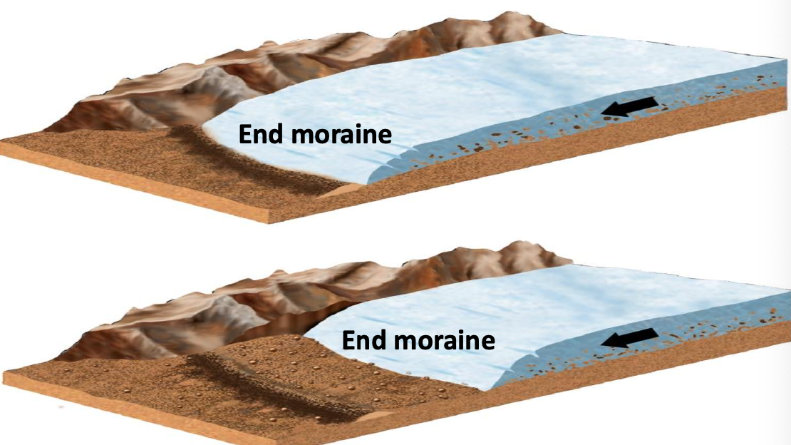
- Terminal moraine: no longer active end moraine that marks furthest advance of a retreating glacier
- Terminal moraine: no longer active end moraine that marks furthest advance of a retreating glacier
- End moraine: ridge of sediment at the nose of the glacier added to repeatedly by the annual advances and retreats of a glacier
When hiking in Alpine regions you will see many different types of moraines not covered in vegetation
Some moraines are still active, and others are not.
A Famous Terminal Moraine?:
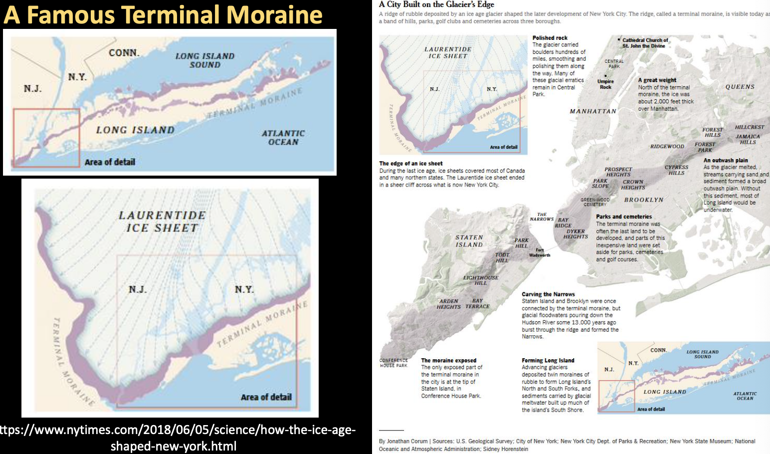
How the Ice Age Shaped New York
Last Glacial Maximum
- ~12,000 years ago North America was covered by ice
- Glaciers responsible for most of area’s topography
- Carving evident in western mountain ranges
- Great Lakes carved by glaciers and filled with meltwater
- Hudson Bay is a depression formed by weight of ice
- Mississippi River and groundwater reserves formed by glacial meltwater
- Glacial sediments formed fertile lands of midwest
Ice Ages and Possible Causes
- Several periods of extensive continental glacial coverage (i.e., ice ages) have occurred even in the recent geologic past (from 2 million to 10000 years ago, Pleistocene)
- Interglacial periods: when ice sheets retreat; currently, we are in an interglacial period
- Possible causes can be from events on Earth or externally
- Solar energy output or sunspot activity (not likely, hard to prove)
- Breakup of Pangaea and isolation of poles (but only for Pleistocene ice ages)
- Evolution of land plants and reduction in atmospheric
- Intense volcanic activity with dust and sulfuric-acid emissions (data needed)
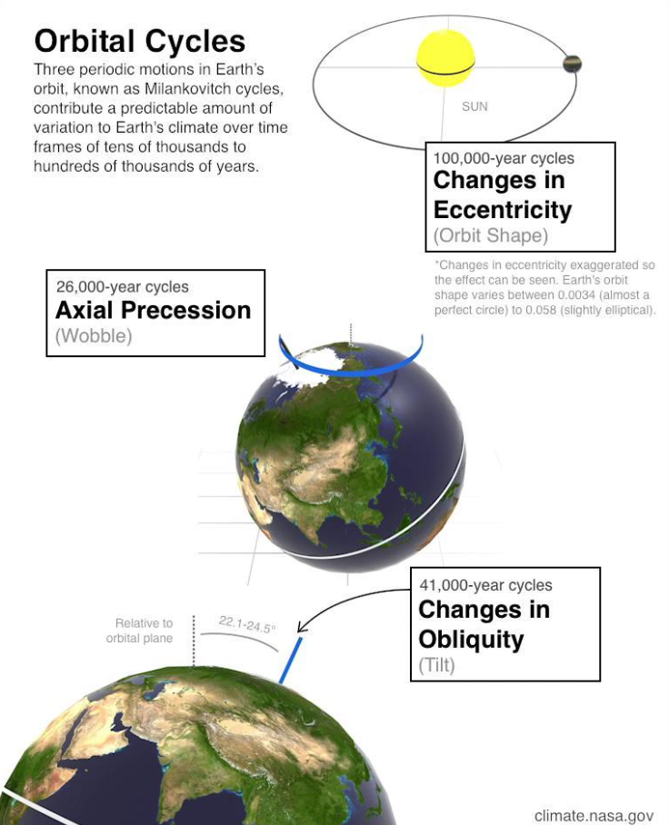
- Best evidence available is for the Milankovitch Cycles of the Earth’s orbit around the sun
- Shape of orbit varies every 100,000 years
- Earth’s axial tilt varies every 41,000 years
- Earth’s axis wobbles (precession cycle) every 26,000 years
- All cycles would affect solar heat distribution globally
- Climate records of temperature and sea-level variations suggest MC can account for advance and retreat but not initiation of an ice age
Wind and Deserts
Wind in Geologic Context
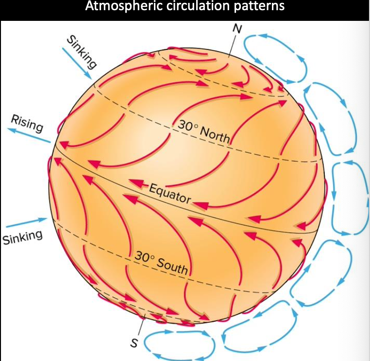
- Air moves along the Earth’s surface in response to air pressure differences, which are often related to surface temperature differences (i.e., solar heating)
- Movement complicated by the fact that land and water absorb heat differently (land varies more than water)
- Air can erode, transport, and deposit material
- Wind accounts for a minor amount of sediment erosion and transport, but regionally it is very important.
Wind Erosion
- Wind erosion most effective on exposed sediments
- Wind transport may be major or only means in deserts
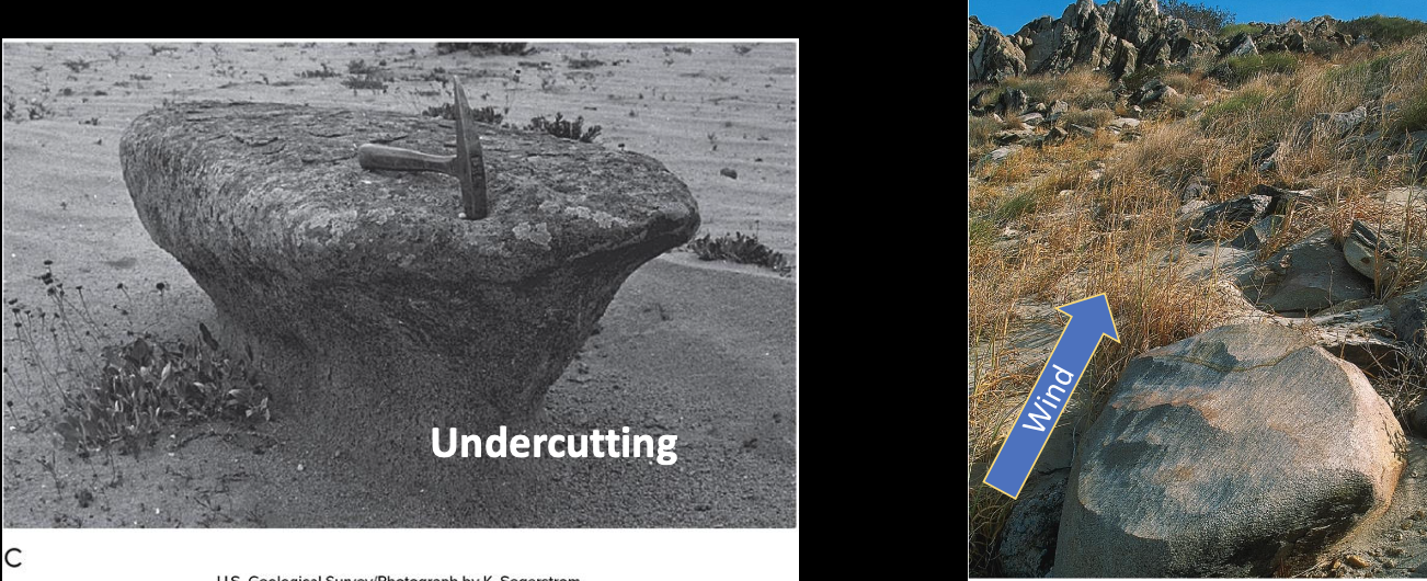
- Abrasion: wearing away of a solid object by impact of wind-blown particles, forming ventifacts, which are ‘wind-made’ rocks
- Deflation: removal of loose (fine-grained) sediment by wind; leaves coarse ones behind
- Vegetation blocks wind
- Keeps fine-grained sediments
- Desert pavement: larger rocks protect sand below; creates a stable surface
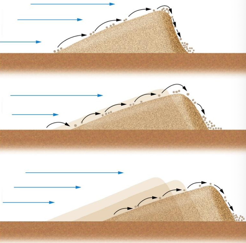
- Dune: ridge of particle (sand commonly); principal feature of wind deposition
- Sediment size deposition based on velocity
- Once a dune starts to form, it acts as an obstacle to wind and collects more
- Dunes can be 3 to 100+m high
- Dunes can migrate with the wind direction
- Particles move up shallower windwards side by saltation, then fall down the steep slip face
- Loess: deposit of windblown silt (very fine grained, easy to carry)
- Silt from glacial meltwater or deserts
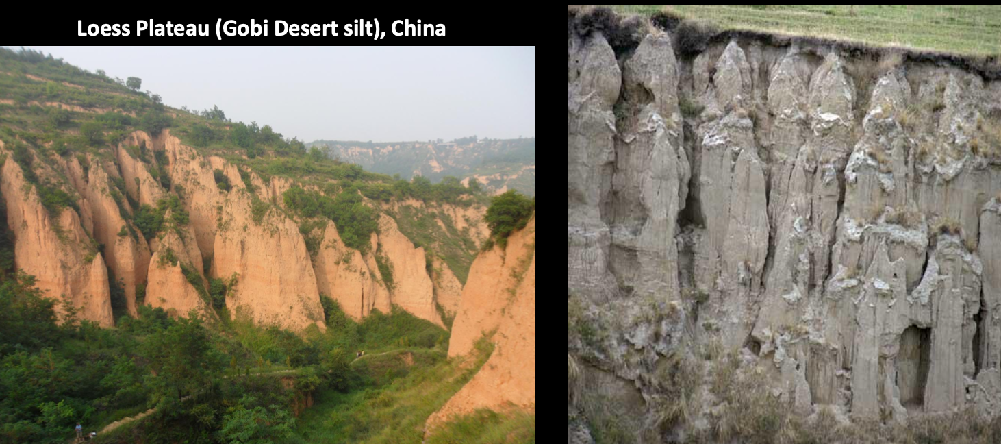
- Right side is South Island of New Zealand
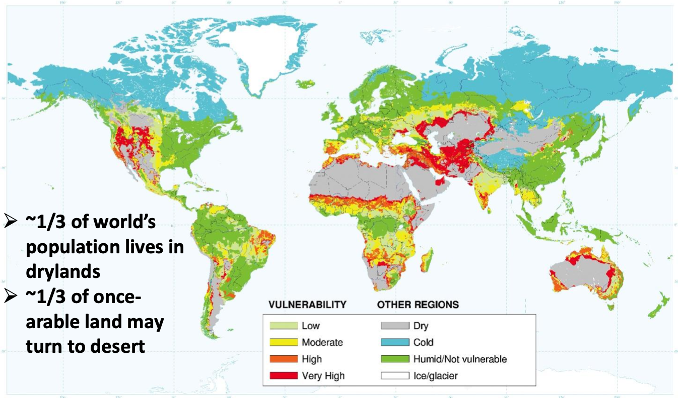
Deserts
Deserts
Region with so little vegetation that limited life is supported
- Sand or rock
- Hot or cold
- Dry or wet
Distribution of arid regions
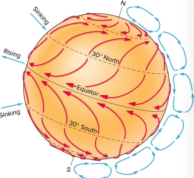
- Location of natural arid deserts mostly due to warmer temperatures and higher air pressures, both which allow the atmosphere to hold more water
- Mostly occur near N&S where the air pressure is high, so it sinks and warms causing evaporation (i.e., drying the land the below)
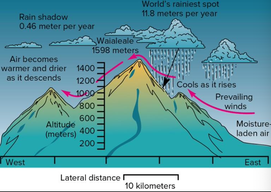
- Location of natural deserts may be due to topography
- Air moving from the oceans inland carries water and is forced to rise and get colder rain
- Most of the water is released on the ocean side and the back side of the mountain is left with dry air a rain shadow
- Interior continental deserts result of distance from ocean
- Coastal deserts occur where cool ocean air that holds more water abuts hot continents
- West coast of South America and Africa
- Polar deserts occur because air reaching poles is relatively dry and becomes even colder, holding more water
- Limited evaporation from nearby oceans contributes to the little snow that falls there
- Almost all of Antartica is a desert
Desertification
Rapid development or expansion of deserts caused or accelerated by humans, mostly land use practices
Arid and semi-arid lands have limited rainfall and vegetation, which helps keep soils somewhat moist and protected from wind erosion
Vegetation may be cleared for food, shelter, energy livestock grazing, or to grow crops
Crops may not be resilient enough to survive a drought, which leads to desertification that can be irreversible