Coastal Zones and Processes
Costal Populations
Worldwide
- In 2000, 1.3 billion people lived within 20km of a marine shoreline with an average density 2.2 times the global average
Coastal Zones of USA
- 30 of the 50 states about abut a major body of water (Atlantic or Pacific Ocean, Gulf of Mexico, one of the Great Lakes)
Coastal Zone of Canada
- In 2001, 11.5 million people (38.3% of the Canadian population) lived within 20 km of a coast, including Great Lakes
Hurricane Fiona hit Canada on September 24, 2022
- Most intense tropical (post-tropical cyclone) storm to hit Canada ever!
- Hurricane-force winds and one of wettest storms ever recorded in Canada.
- Impacted Nova Scotia, New Brunswick, PEI, Newfoundland, and Quebec
Hurricane/Superstrom Sandy:
- $65 Billion USD damage to USA
- $100 Million CAD damage to ON & QC Killed 233 people in 8 countries
Beaches - most prominent feature of a coast
- A beach is a gently sloping surface washed over by waves and covered by sediment
- The beach face is the portion regularly washed by the waves as tides rise and fall
- The berm is the flatter part of the beach landward of the beach face
What Impacts the Geology of a Coastline?
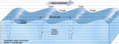
Waves
- The wind pushes against surface water and the energy is transmitted in waves along the surface
- Water particle motion is in circular orbits - largest orbits at the surface and they get smaller with depth
- When the wave feels the bottom and the orbits are disrupted, the wave breaks and forms breakers
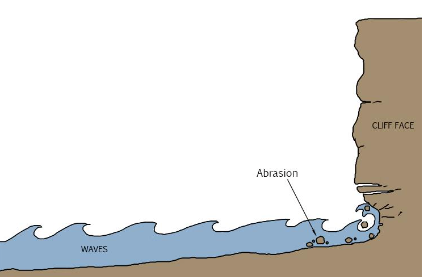
Waves and erosion
- Coastal rock erosion is from either direct pounding by breakers or milling/abrasion
- Milling/abrasion – grinding effect of sand, pebbles, etc. on other rock
- E.g., on the cliff face in the coastal ocean
- Pebbles and rocks could be sources from the direct erosion of the breaking waves
Currents
Currents
Currents – large movement of water in one general direction, at surface or depth, and can be temporary. Check this out: https://earth.nullschool.net/#current/ocean/surface/currents/overlay=significant_wave_height/orthographic=-90.81,34.53,414
Tides
Tides
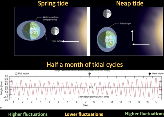
Tides – rise and fall of water levels in ocean (and large lakes) resulting from gravitational pull of the moon and the sun
- Closer the object, more gravitational pull ⇒ moon has most pull
- Tides occur twice a day, 12 hrs and 25 mins apart (half a lunar day), when a location is in line with the moon’s gravitational pull
- 2 high tides and 2 low tides each lunar day
- High tides reach further up the beach
Types of tides:
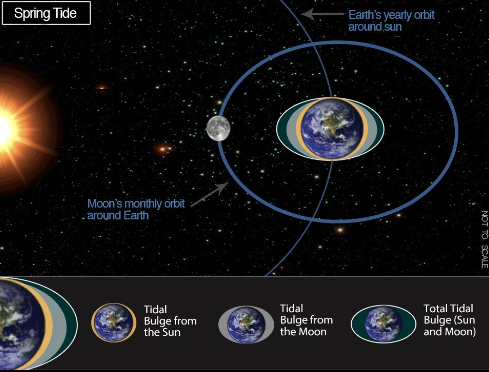
- Spring tides – occur when sun, moon, and earth are aligned (full and new moons) and have highest tidal fluctuations
- Neap tides – occur when sun and moon are pulling at right angles to each other and have lowest tidal fluctuations
Each happen twice in a lunar cycle (a month)
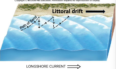
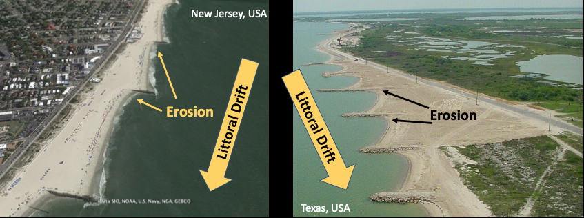
Longshore Currents
- Waves and currents move sediment; faster and more energetic the wave or current and the larger the sediments that can be moved
- Waves can induce currents (general movement of water in a direction)
- Waves hitting a beach at an angle causes longshore current
- Sediments moves onto beach at an angle with waves but also pushed down the beach with the longshore current
- Net result is littoral drift of sediments down the beach
- Beach must be replenished by wave erosion, stream delivery, or blown dune sand
Storms
-
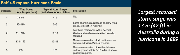
Storm surge - unusual increase in local sea level due to a storm, primarily the winds pushing water onshore and low pressure allowing a bulge in water level
-
Storm tide - overall water level from storm surge and tides
-
Surges cause flooding and massive beach erosion
-
Surges cause flooding and massive beach erosion
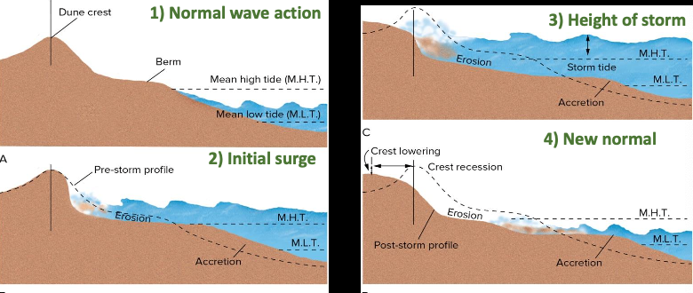
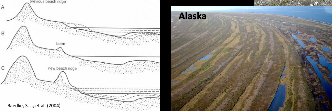
Coastlines are constantly changing
- Waves, currents, tides, storms influence sediment transport and deposition along a coastline
- Can erode or build beaches
- When sediment is plentiful the beach can build outwards via beach ridges
Short vs. Long timescale changes:
- Relatively shorter timescale changes obvious on beaches
- Sediment transport
- Erosion
- Beach ridges
- But longer timescale changes also occur - just are not as obvious
- Sea level change
Characterizing Coastline Geologically
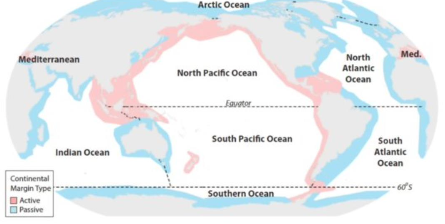
- Coastline shaped by tectonic setting, materials present, and water energy
- Plate tectonics influences coastline geometry
- Active margin: active plat boundary with subduction and transform faulting
- Cliffs; Narrow continental shelf; Steep offshore drop
- Passive margin: not at an active plate boundary
- Broad beaches; Wide continental shelf; Sandy offshore (barrier) islands
- Broad beaches; Wide continental shelf; Sandy offshore (barrier) islands
- Active margin: active plat boundary with subduction and transform faulting
Emergent vs. Submergent Coastline
- Signs of changing relative or local sea level
- Active continental margins may uplift and produce an emergent coastline
- A wave-cut platform is an erosional feature on an emergent coastline
- A number of wave-cut platforms is an indication of uplifting land or dropping sea level
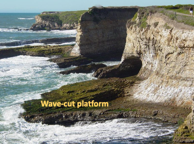
- A number of wave-cut platforms is an indication of uplifting land or dropping sea level
- Loading of the crust can produce submergent coastlines
- Glacial melt could cause sea level rise
- A drowned valley is indicative of sea level rise
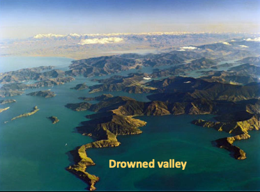 Submergent coastline Fjords of Norway
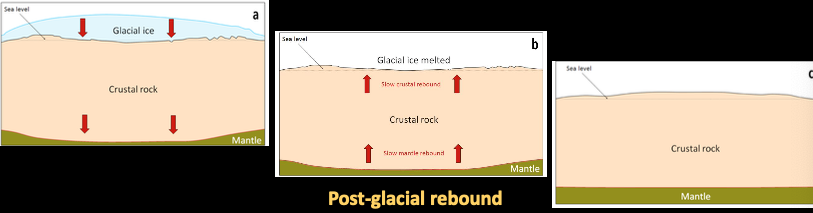
Post-glacial Rebound
Long-term sea-level changes often are associated with plate tectonics
- Warm lithosphere takes up more volume than cold crust
- Tectonics events could cause abrupt uplift (several meters in matter of seconds)
- Lithosphere is buoyant and responds to weight, like ice sheets or sediment
- Melting of glaciers and expanding of warmer oceans increase sea level
- Direct human impact - water or oil extraction land subsidence
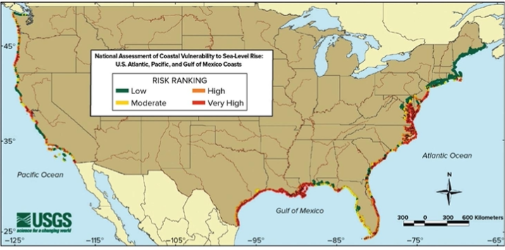
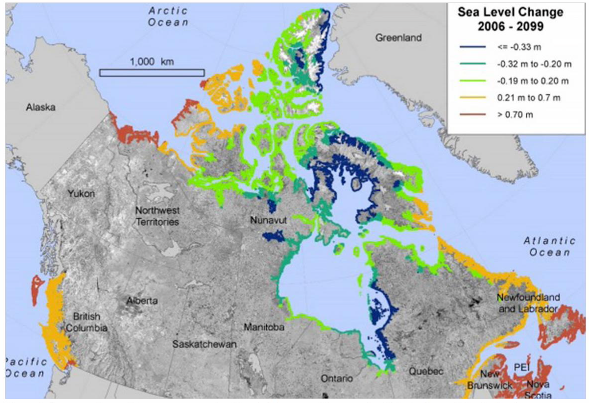
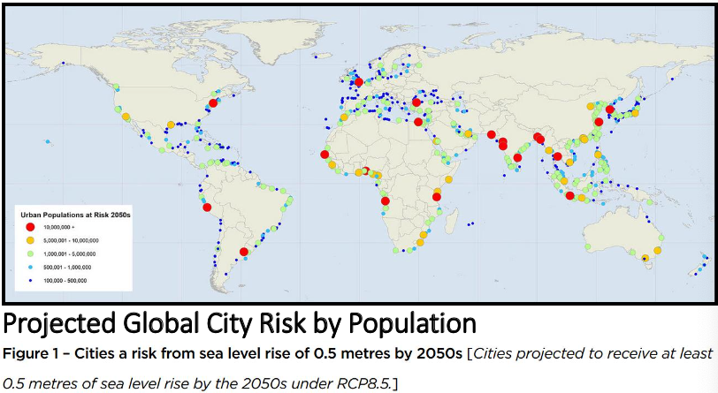
Projected Sea Level Rise (2100)
Stabilizing the coast
- Natural, undeveloped coastlines reach an equilibrium between sediment addition and removal
- Humans try to control the natural flux along a coast by
- Hard structural stabilization: construction of solid structures
- Soft structural stabilization: soft manipulation, like sand replenishment or dune building
- Nonstructural stabilization: land-use restrictions (similar to restrictive zoning)
Stabilizing beaches
-
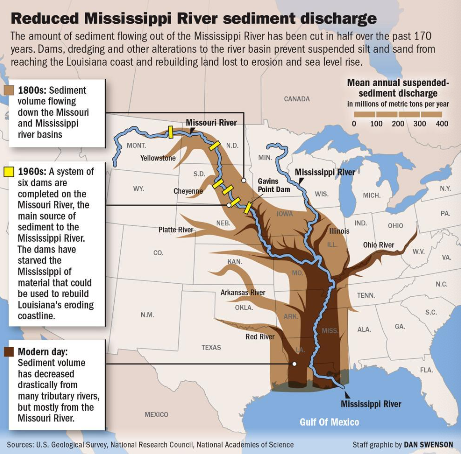
A groin or jetty - long, narrow obstacle perpendicular to shore - used to prevent littoral drift
-
Result in scallop shaped beaches and can cause more harm in the eroding zones
-
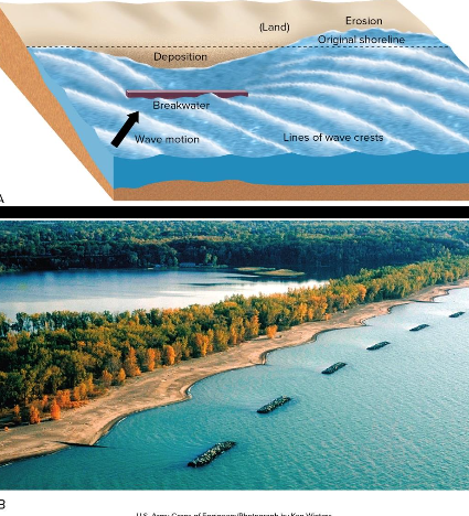
Breakwater: island built offshore to moderate wave action on a beach
-
Deposition occurs behind breakwater
-
Erosion occurs down-current
-
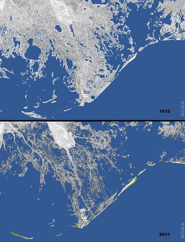
Dams far upstream from the coast can impact coastal beaches, wetlands, islands, etc. by holding back sediment that should be flowing to the ocean
-
Instead, islands form in reservoirs and dams need to be dredged constantly
-
Mississippi River only releases ~50% of its natural sediment load to Gulf of Mexico because of upstream damming
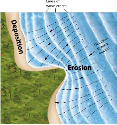
-
Louisiana’s wetlands have suffered dramatically
-
Breach nourishment/replenishment: placing sand onto an eroding shoreline to widen (or sometimes create) a beach
-
Often takes constant maintenance and money
-
If using different sediments, could impact ecology
Cliff Erosion
- Sandy cliffs are vulnerable to wave and current action
- Undercutting and slumping common
- Headlands are particularly vulnerable because of wave refraction
- deflection of waves around irregularities in coastline concentrates wave action on a headland
- deflection of waves around irregularities in coastline concentrates wave action on a headland
Preventing cliff erosion is basically futile but can try wit riprap or seawalls.
Seawall may prevent some damage to the cliffs but suffer itself and need to be maintained.
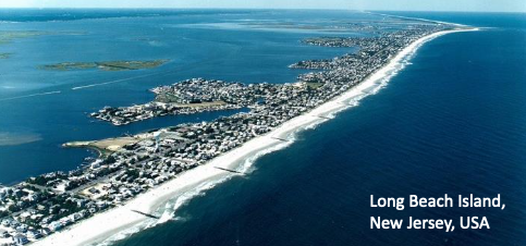
Barrier Islands
-
Barrier Islands: Long, low, narrow islands paralleling a coastline
-
Formation unknown
-
First line of defense against storm waves
-
Barrier islands slowly retreat landward
-
Avg 2 m/y on USA Atlantic coast
-
Up to 20 m/y has been recorded
-
In USA, 20% of barrier island area is developed
-
Stabilization projects on barrier islands are expensive and futile
-
346,000 coastal homes in NJ damaged by Hurricane Sandy
Estuaries
Estuary
A body of water along a coastline and open to the sea
- Experiences tides and has brackish water (mix of fresh and salt)
- Extremely productive regions, full of wildlife adapted to brackish water
- Changes in salinity has major ecological implications
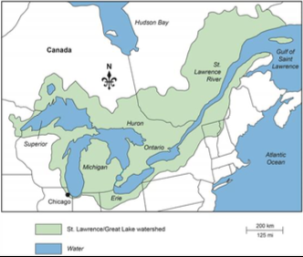
- Estuary land often reclaimed There are >1200 estuaries worldwide. The Largest in the world: St. Lawrence estuary Quebec, Canada.
Costs of (re)construction in Coastal Environments
- Federal funds available for flood insurance in USA
- But should we build (and rebuild) in these areas and use federal money?
- Beach replenishment must be done every few years and costs millions
- Should tax dollars be spent on it over and over again?
- Knowledge of local coastal dynamics, especially historical, should be considered when deciding where to build or rebuild.